
File:Near east lrg.jpg

本预览的尺寸:451 × 599像素。 其他分辨率:181 × 240像素 | 361 × 480像素 | 578 × 768像素 | 771 × 1,024像素 | 1,542 × 2,048像素 | 2,987 × 3,967像素。
原始文件 (2,987 × 3,967像素,文件大小:2.62 MB,MIME类型:image/jpeg)
| 描述 |
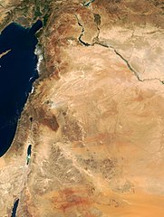
This true-color image of the region was taken on September 10, 2000, by the MODerate-resolution Imaging Spectroradiometer (MODIS) flying aboard NASA's Terra spacecraft. The image shows the lands of Israel along the eastern shore of the Mediterranean Sea, with the countries of Jordan to the southeast and Syria to the Northeast. The region known as the West Bank lies between the two countries. Running from north to south, the Jordan River links the Sea of Galilee to the Dead Sea. Click the image to enlarge it, and to see the borders drawn in. Image courtesy Jacques Descloitres, MODIS Land Group, NASA GSFC |
| 日期 | image taken on 10. Sep. 2000 |
| 来源 | http://earthobservatory.nasa.gov/Newsroom/NewImages/Images/modis_near_east_lrg.jpg |
| 作者 | NASA, earthobservatory, http://earthobservatory.nasa.gov/ |
| 授权 (二次使用本文件) |
PD-USGov-NASA |
| 本文件完全由NASA创作,在美国属于公有领域。根据NASA的版权方针,NASA的材料除非另有声明否则不受版权保护。(参见Template:PD-USGov/zh、NASA版权方针页面或JPL图片使用方针。) | ||
 |
警告:
|
文件历史
点击某个日期/时间查看对应时刻的文件。
| 日期/时间 | 缩略图 | 大小 | 用户 | 备注 | |
|---|---|---|---|---|---|
| 当前 | 2015年2月5日 (四) 20:27 | | 2,987 × 3,967(2.62 MB) | Capricorn4049 | Cropped < 1 % horizontally and 1 % vertically using CropTool with precise mode. |
| 2005年6月5日 (日) 09:29 |  | 3,002 × 4,002(1.96 MB) | Prolineserver | near east, PD-USGov-NASA |
文件用途
全域文件用途
以下其他wiki使用此文件:
- ar.wikipedia.org上的用途
- arz.wikipedia.org上的用途
- ast.wikipedia.org上的用途
- ba.wikipedia.org上的用途
- ca.wikipedia.org上的用途
- ckb.wikipedia.org上的用途
- el.wikipedia.org上的用途
- en.wikipedia.org上的用途
- eo.wikipedia.org上的用途
- eo.wikiquote.org上的用途
- es.wikipedia.org上的用途
- eu.wikipedia.org上的用途
- fa.wikipedia.org上的用途
- fr.wikipedia.org上的用途
- gl.wikipedia.org上的用途
- he.wikipedia.org上的用途
- id.wikipedia.org上的用途
- is.wikipedia.org上的用途
- it.wikipedia.org上的用途
- ja.wikipedia.org上的用途
- kbp.wikipedia.org上的用途
- ko.wikipedia.org上的用途
查看本文件的更多全域用途。