特萊平原
| 此條目需要擴充。 (2017年2月25日) |


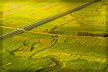
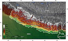
特萊平原(印地語:तराई;尼泊爾語:तराइ;英語:Terai,印地語和尼泊爾語中意為「濕谷,山腳低地」[1][2][3][4][5][6]),也譯作德賴平原,是印度河-恆河平原北部的尼泊爾-印度交界處的一處低地地區。北靠喜馬拉雅山脈及西瓦利克山脈。該地區主要為草原、疏林草原、娑羅樹林及沼澤組成。海拔在60-300米左右。為亞熱帶氣候。
奇特旺國家公園及巴爾迪亞國家公園(Bardiya National Park)位於該區域。這里以前主要居民是塔魯族,在根除瘧疾後中部丘陵地區民族大舉南下,巴洪和切特里也成為主要居民。
在尼泊爾,特萊是經濟生產力最高的地區。尼泊爾的大多數主要產業都位於該地區。這裏種植水稻、小麥、豆類、甘蔗、黃麻、煙草和玉米。整個地區建立了許多農產工業,如黃麻廠、糖廠、碾米廠和煙草廠。
參見[編輯]
| 維基導遊上的相關旅行指南:德賴平原 |
參考資料[編輯]
- ^ Ronald Stuart McGregor. The Oxford Hindi-English Dictionary. London: Oxford University Press. 1993: 441 [2021-08-22]. ISBN 9780198643395. (原始內容存檔於2021-08-22).
- ^ Sir Ralph Lilley Turner. A comparative dictionary of Indo-Aryan languages. London: Oxford University Press. 1962-1966: 324 [2021-08-22]. ISBN 9788120816657. (原始內容存檔於2021-08-22).
- ^ John Thompson Platts. A dictionary of Urdu, classical Hindi, and English. London: W. H. Allen & Co. 1884: 316 [2021-08-22]. ISBN 9781497907805. (原始內容存檔於2021-11-16).
- ^ Sir Ralph Lilley Turner. A comparative and etymological dictionary of the Nepali language. London: K. Paul, Trench, Trubner. 1931: 274 [2021-08-22]. ISBN 9788183630115. (原始內容存檔於2021-08-22).
- ^ Ruth Laila Schmidt. A Practical dictionary of modern Nepali. Ratna Sagar. 1994: 277 [2021-08-22]. ISBN 9788170701729. (原始內容存檔於2021-08-22).
- ^ S. W. Fallon. A new Hindustani-English dictionary, with illustrations from Hindustani literature and folk-lore. London: Trubner and Co. 1879: 408 [2021-08-22]. ISBN 9788120603738. (原始內容存檔於2021-08-22).
- ^ The Oxford English Dictionary, Volume 17 2, reprint. Clarendon Press. : 794. ISBN 9780198611868.
- ^ terai hat. Dictionary.com BASED ON THE RANDOM HOUSE UNABRIDGED DICTIONARY, © RANDOM HOUSE, INC. [2021-08-22]. (原始內容存檔於2021-08-22).
