
File:Basin of Mexico 1519 map-en.svg

此 SVG 檔案的 PNG 預覽的大小:449 × 599 像素。 其他解析度:180 × 240 像素 | 360 × 480 像素 | 576 × 768 像素 | 768 × 1,024 像素 | 1,536 × 2,048 像素 | 1,412 × 1,883 像素。
原始檔案 (SVG 檔案,表面大小:1,412 × 1,883 像素,檔案大小:526 KB)
摘要
| 描述 |
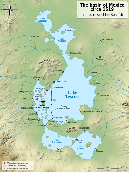
English: Map of the basin of Mexico circa 1519, at the arrival of the Spanish.
Español: Mapa de la cuenca de México acerca 1519, a la llegada de los españoles
Français : Carte du bassin de Mexico vers 1519, à l'arrivée des Espagnols. |
| 日期 | (UTC) |
| 來源 |
|
| 作者 |
|
| 其他版本 |
[]
|
| SVG開發 | 這個SVG 檔案使用了內置文字,可以使用任何文字編輯器輕鬆翻譯。 |


| 拍攝地點 | | 位於此地的本圖片與其他圖片: OpenStreetMap |
|---|
授權條款
我,本作品的著作權持有者,決定用以下授權條款發佈本作品:
| 公共版權:本藝術作品是自由的,您可以依據自由藝術作品許可協議的條款傳播和/或修改本藝術作品。您可以在Copyleft Attitude網站或其他網站找到該許可協議的樣本。 |
This file is licensed under the Creative Commons Attribution-Share Alike 4.0 International, 3.0 Unported, 2.5 Generic, 2.0 Generic and 1.0 Generic license.
- 您可以自由:
- 分享 – 複製、發佈和傳播本作品
- 重新修改 – 創作演繹作品
- 惟需遵照下列條件:
- 姓名標示 – 您必須指名出正確的製作者,和提供授權條款的連結,以及表示是否有對內容上做出變更。您可以用任何合理的方式來行動,但不得以任何方式表明授權條款是對您許可或是由您所使用。
- 相同方式分享 – 如果您利用本素材進行再混合、轉換或創作,您必須基於如同原先的相同或兼容的條款,來分布您的貢獻成品。
您可以選擇您需要的授權條款。
原始上傳日誌
This image is a derivative work of the following images:
- File:Lago_de_Texcoco-posclásico.png licensed with PD-self, PD-self/fr
- 2006-09-19T01:46:06Z Yavidaxiu 1412x1644 (344123 Bytes) {{Information |Description={{es|Mapa de la cuenca de México a la llegada de los españoles}} |Source=Trabajo propio |Date=18 de septiembre de 2006 |Author=Yavidaxiu |Permission={{PD-self}} |other_versions= }} [[Category:Map
- File:Valley_of_Mexico_c.1519-fr.svg licensed with Cc-by-sa-2.5,2.0,1.0, Cc-by-sa-3.0-migrated, GFDL
- 2007-09-11T14:00:14Z Historicair 731x849 (270643 Bytes)
- 2007-09-11T13:51:30Z Historicair 731x849 (272818 Bytes) {{Information |Description={{fr|Les environs de Tenochtitlan vers 1519}} {{en|Valley of Mexico circa 1519}} |Source=Own work |Date=11/09/2007 |Author=~~~~ |Permission={{self2|GFDL|cc-by-sa-2.5,2.0,1.0}} |other_versions= }} {{
Uploaded with derivativeFX
檔案歷史
點選日期/時間以檢視該時間的檔案版本。
| 日期/時間 | 縮圖 | 尺寸 | 用戶 | 備註 | |
|---|---|---|---|---|---|
| 目前 | 2021年1月28日 (四) 20:29 | | 1,412 × 1,883(526 KB) | Sémhur | Huexotla <=> Coatlinchán |
| 2013年7月17日 (三) 05:40 |  | 1,412 × 1,883(525 KB) | Citypeek | Enlargement of the legenda in the upper right corner. | |
| 2013年7月17日 (三) 05:33 |  | 1,412 × 1,883(533 KB) | Citypeek | Corrected two errors. Valid SVG now. | |
| 2010年2月8日 (一) 18:37 |  | 1,412 × 1,883(533 KB) | Sémhur | + relief and some improvements | |
| 2010年1月31日 (日) 09:45 |  | 1,412 × 1,645(99 KB) | Sémhur | == {{int:filedesc}} == {{Information |Description= {{en|Map of the basin of Mexico circa 1519, at the arrival of the Spanish.}} {{es|Mapa de la cuenca de México acerca 1519, a la llegada de los españoles}} {{fr|Carte du bassin de Mexico vers 1519, à l |
檔案用途
沒有使用此檔案的頁面。
全域檔案使用狀況
以下其他 wiki 使用了這個檔案:
- azb.wikipedia.org 的使用狀況
- ba.wikipedia.org 的使用狀況
- br.wikipedia.org 的使用狀況
- de.wikipedia.org 的使用狀況
- en.wikipedia.org 的使用狀況
- Aztecs
- Iztapalapa
- Lake Texcoco
- Valley of Mexico
- Aztec Empire
- Altiplano Cundiboyacense
- Tenayuca
- User:Kazkaskazkasako/Books/History
- User:Maunus/sandbox
- List of conflicts in Mexico
- Lake Zumpango
- Lake Tauca
- User:SomeGuyWhoRandomlyEdits/List of conflicts in Mexico
- Sierra de Guadalupe, Mexico
- Battle of Colhuacatonco
- en.wikibooks.org 的使用狀況
- es.wikipedia.org 的使用狀況
- fi.wikibooks.org 的使用狀況
- hr.wikipedia.org 的使用狀況
- hy.wikipedia.org 的使用狀況
- id.wikipedia.org 的使用狀況
- ja.wikipedia.org 的使用狀況
- ka.wikipedia.org 的使用狀況
- la.wikipedia.org 的使用狀況
- nl.wikipedia.org 的使用狀況
- nv.wikipedia.org 的使用狀況
- pl.wikipedia.org 的使用狀況
- rue.wikipedia.org 的使用狀況
- ru.wikipedia.org 的使用狀況
- sv.wikipedia.org 的使用狀況
- ta.wikipedia.org 的使用狀況
- tr.wikipedia.org 的使用狀況
- vi.wikipedia.org 的使用狀況