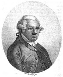
亞歷山大·達爾林普爾


英國皇家學會會員亞歷山大·達爾林普爾(英語:Alexander Dalrymple,1737年7月24日—1808年6月19日),蘇格蘭地理學家,英國東印度公司和英國皇家海軍首席水文師。 [1]他繪製了幾千張海圖,對許多海洋首次進行了標註,因而對航行安全貢獻巨大。他提出在南太平洋存在一個「未知南方大陸」的假說,激勵了大批探險家遠航尋找傳說中的陸地,直到庫克船長在其第二次航行後(1772–1775)得出結論:如果這塊陸地確實存在,那麼它應該在南緯65°線以南。[2]
生平[編輯]
亞歷山大·達爾林普爾於1737年出生於蘇格蘭愛丁堡東郊馬瑟爾堡的紐海爾斯(英語:Newhailes)莊園,有兄弟姊妹15個,他排行第十一。[3]
- 1752年來到英國倫敦,被任命為英國東印度公司的撰寫文員, 1753年來到印度馬德拉斯赴任。他很快熱衷於和東印度及中國的貿易。
- 1759年,22歲的達爾林普爾訪問了中國廣州。他多次乘船往返於印度、中國等地,具有實際航行經驗。他和助手們的工作主要負責匯整、分析各地船隻帶回的日誌或探勘報告,結合其他信息,繪製亞洲各貿易區域的最新海圖,也不時出版水文專著。
- 1760年,達爾林普爾隨英國東印度公司的船隊對中國海南島東南沿岸測量各種水文資料。
- 1762年9月,達爾林普爾與蘇祿蘇丹Bantilan Muizzud-Din簽訂協議,蘇祿蘇丹國將北婆羅洲古達(英語:Kodat)以北、邦吉島西邊的巴蘭邦岸島[4](英語:Balambangan)讓與英國。[5]
- 1763年,達爾林普爾在英國和蘇祿蘇丹簽定合約後,代表英國佔據了巴蘭邦岸島,在此設立一個貿易站。達爾林普爾想通過海圖重構,來論述巴蘭邦岸及其附近島礁的方位,並提醒英國需要進一步航海檢驗。海圖繪製依據:1752–1765年35艘船的航行記錄,並採用大量的前人資料,反覆比對自己的觀測,根據基準點對航線做了矯正。
- 1764年,被馬尼拉理事會選為臨時代理總督。[6]
- 1765年返回倫敦,當選為英國皇家學會會員。達爾林普爾的航行筆記說明了測量海上風速對於水手很有意義,直接啟發了關於風速等級的研究,其中英國海軍少將、水道測量專家弗朗西斯·蒲福(英語:Rear Admiral Sir Francis Beaufort,1774–1857)創立的蒲福風級(英語:Beaufort scale)沿用至今。
- 發表「1770–1771年間南太平洋的若干航行與發現歷史」, 庫克船長(英語:James Cook)被委託領導南太平洋的探索,他發現了澳大利亞東海岸。
- 1772年出版第一批海圖, 其中四張是在蘇祿群島周圍。
- 1779年,擔任英國東印度公司水文部首席水文師。
- 1782年,當選為瑞典皇家科學院外籍院士。
- 1795年,擔任英國皇家海軍水文部首席水文師。
- 1808年病逝於英國。兩年後,英國東印度公司聘請詹姆士·霍爾斯堡[7](英語:James Horsburgh,1762–1836)接任水文師。他亦是蘇格蘭人。
著作年表[編輯]
- 1768 Memoir of a Chart of the Southern Ocean
- 1771 第一版中國海海圖記事
- 1771 Memoir of a chart of the bay of Bengal, published at the expence of the United East-India Company
- 1784 中國海灘礁列舉 Account of shoal in the China sea
- 1785 Memoir Concerning the Chagos and Adjacent Islands
- 1786 第二版中國海海圖記事 附錄76個島礁灘名稱
- 1786 Memoir of the Chart of the Straits of Sunda and Banka, Scale 3 Inches
- 大約1790. Practical Navigation. Printer's proof. National Library of Scotland.
- 1792 Memoir on the Watering the Circars
- 1803 Memoir of a Chart of the N.W. Coast of Madagascar
- 1806 Memoir concerning the geography of the countries situated on Rio de la Plata, and on the rivers falling into it. [With] Directions for the mouth of Rio de la Plata, by D.P. Bouverie [&c.]. Alexander Dalrymple. Duncombe Pleydell Bouverie
- 《中國海海圖》,本圖題贈達普萊·德·曼納維耶特先生,「東方海王號」的天才作者,以表彰他對航行的貢獻,也感謝他給予達爾林普爾的許多指導。
- 《東方航海指南》,全稱:「繞過好望角後的國家海上貿易航海圖集」 -- 根據達普萊·德·曼納維耶特「東方海王號」最新出版物繪製,含大量增補,精選自「英國東印度公司」多種航海日誌。
- 達爾林普爾的海圖說明資料匯編,1786年第2版
- 這11本資料中,與南海相關的是3本:第一版中國海海圖筆記1771、中國海灘礁列舉1784、第二版中國海海圖筆記1786。其中「中國海灘礁列舉」,列在第3本的四頁附錄:76個島礁灘名稱。
參考資料[編輯]
- ^ Britannica: Alexander Dalrymple, British geographer and hydrographer. [2020-09-28]. (原始內容存檔於2020-07-29).
- ^ Wikipedia: Alexander Dalrymple. [2020-09-28]. (原始內容存檔於2020-05-26).
- ^ Dictionary of National Biography, Dalrymple, Alexander (1737–1808), hydrographer by Andrew S. Cook
- ^ Wikipedia: Balambangan Island. [2020-09-28]. (原始內容存檔於2020-08-06).
- ^ Warren, James Francis (1981). The Sulu Zone, 1768-1898: The Dynamics of External Trade, Slavery, and Ethnicity in the Transformation of a Southeast Asian Maritime State. Singapore: NUS Press. pp. 18-19.
- ^ Tracy, Nicholas (1995). Manila Ransomed. University of Exeter Press. ISBN 0859894266.
- ^ Wikipedia: James Horsburgh. [2020-09-28]. (原始內容存檔於2020-04-20).
- Phillimore, Colonel R.H. Historical records of the Survey of India. Volume I 18th century.. Dehra Dun: Survey of India. 1945: 330–331.
- Australian Dictionary of Biography. Vol.1 :1788-1850. 1966 Melbourne University Press.
- Dalrymple, Alexander (ca. 1790). Practical Navigation. Printer's proof. National Library of Scotland, shelfmark Nha.M90 (3)
- Friendly, Alfred. Beaufort of the Admiralty. New York. Random House, 1977
- Huler, Scott (2004). Defining the Wind: The Beaufort Scale, and How a 19th-Century Admiral Turned Science into Poetry. Crown. ISBN 978-1-4000-4884-7
- Howard T. Fry, Alexander Dalrymple (1737-1808) and the Expansion of British Trade, London, Cass for the Royal Commonwealth Society, 1970. ISBN 0-7146-2594-9
外部連結[編輯]
| 維基文庫中該作者的作品: 亞歷山大·達爾林普爾 |
- Portrait of Alexander Dalrymple, National Museum of Scotland
- Historical Collection of the Several Voyages and Discoveries in the South Pacific Ocean (1770–1771). (Canadiana and Internet Archive make available digitised scans taken from microfiche which were in turn filmed from volumes held at Thomas Fisher Rare Book Library, in the University of Toronto Library. Other libraries also hold physical copies of the original books.) IA Open Library(頁面存檔備份,存於互聯網檔案館), WorldCat 5258438(頁面存檔備份,存於互聯網檔案館)
- Volume I, Being chiefly a literal translation from the Spanish writers: Canadiana(頁面存檔備份,存於互聯網檔案館), Internet Archive.
- Volume II, Containing the Dutch voyages. Canadiana(頁面存檔備份,存於互聯網檔案館), Internet Archive.
| ||||||||||||||||||||||||||||||||
