
File:Flevoland position.svg

此 SVG 檔案的 PNG 預覽的大小:200 × 236 像素。 其他解析度:203 × 240 像素 | 407 × 480 像素 | 651 × 768 像素 | 868 × 1,024 像素 | 1,736 × 2,048 像素。
原始檔案 (SVG 檔案,表面大小:200 × 236 像素,檔案大小:157 KB)
摘要
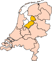
| 描述 | Location of the province of Flevoland in the Netherlands. |
| 日期 | |
| 來源 | Own work, based on freely available GIS data |
| 作者 | User:Mtcv |
| 授權許可 (重用此檔案) |
Data: attribution required; my work: PD |
| 其他版本 | I attempted to make an svg version of Image:Flevoland-Position.png (with less simplified boundaries) |
Clickable version

授權條款

|
本檔案的著作權持有者,Centraal Bureau voor de Statistiek,在註明所有人姓名的前提下,允許任何人使用本檔案於任何用途。包含再散布、衍生作品、商業用途及其他用途。 |
|
|
| 註解 | 該圖片含有註解:在維基媒體共享資源上查看註解 |


檔案歷史
點選日期/時間以檢視該時間的檔案版本。
| 日期/時間 | 縮圖 | 尺寸 | 用戶 | 備註 | |
|---|---|---|---|---|---|
| 目前 | 2019年3月2日 (六) 17:19 | | 200 × 236(157 KB) | Thayts | update |
| 2006年10月3日 (二) 00:44 |  | 200 × 236(158 KB) | Mtcv | {{Information| |Description=Location of the province of Noord-Holland (North Holland) in the Netherlands. |Source=Own work, based on freely available GIS data |Date=2006-10-03 |Author=User:Mtcv |Permission=Data: attribution required; my work: PD |othe |
檔案用途
全域檔案使用狀況
以下其他 wiki 使用了這個檔案:
- ar.wikipedia.org 的使用狀況
- be-tarask.wikipedia.org 的使用狀況
- br.wikipedia.org 的使用狀況
- en.wikipedia.org 的使用狀況
- eu.wikipedia.org 的使用狀況
- fi.wikipedia.org 的使用狀況
- hi.wikipedia.org 的使用狀況
- hu.wikipedia.org 的使用狀況
- id.wikipedia.org 的使用狀況
- ja.wikipedia.org 的使用狀況
- jv.wikipedia.org 的使用狀況
- lb.wikipedia.org 的使用狀況
- nds-nl.wikipedia.org 的使用狀況
- nn.wikipedia.org 的使用狀況
- pt.wikipedia.org 的使用狀況
- ru.wikipedia.org 的使用狀況
檢視此檔案的更多全域使用狀況。