
File:US Court of Appeals and District Court map.svg

此 SVG 檔案的 PNG 預覽的大小:620 × 402 像素。 其他解析度:320 × 207 像素 | 640 × 415 像素 | 1,024 × 664 像素 | 1,280 × 830 像素 | 2,560 × 1,660 像素。
原始檔案 (SVG 檔案,表面大小:620 × 402 像素,檔案大小:768 KB)
摘要
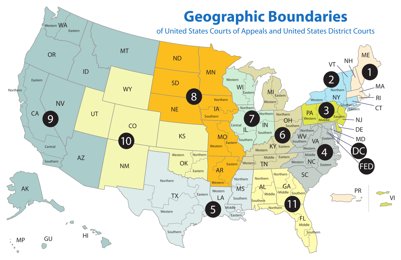
| 描述 | Map of the geographic boundaries of the various United States courts of appeals and United States district courts. |
| 日期 | |
| 來源 | http://www.uscourts.gov/uscourts/images/CircuitMap.pdf |
| 作者 | PDF by the US Government, converted using Texterity's FreeSVG, tweaked using en:Inkscape by Tintazul |
| 其他版本 |
|


授權條款
This work is licensed by the creator under the following conditions:
此檔案採用創用CC 姓名標示-相同方式分享 2.5 通用版授權條款。
- 您可以自由:
- 分享 – 複製、發佈和傳播本作品
- 重新修改 – 創作演繹作品
- 惟需遵照下列條件:
- 姓名標示 – 您必須指名出正確的製作者,和提供授權條款的連結,以及表示是否有對內容上做出變更。您可以用任何合理的方式來行動,但不得以任何方式表明授權條款是對您許可或是由您所使用。
- 相同方式分享 – 如果您利用本素材進行再混合、轉換或創作,您必須基於如同原先的相同或兼容的條款,來分布您的貢獻成品。
The original work from which this is derived is in the public domain for the following reason:
|
|
 |
檔案歷史
點選日期/時間以檢視該時間的檔案版本。
| 日期/時間 | 縮圖 | 尺寸 | 用戶 | 備註 | |
|---|---|---|---|---|---|
| 目前 | 2018年4月17日 (二) 18:58 | | 620 × 402(768 KB) | BenbowInn | DC and FED are circuits too, added black circles to emphasize them, also converted to plain SVG |
| 2006年7月11日 (二) 07:48 |  | 620 × 402(1.14 MB) | Tintazul | {{Tintazul |Description=Map of the geographic boundaries of the various United States Courts of Appeals and United States District Courts. |Source=[http://www.uscourts.gov/image |
檔案用途
超過 100 個頁面有用到此檔案。 下列清單只列出前 100 筆有用到此檔案的頁面。 您也可以檢視完整清單。
- 上海美国法院
- 纽约的法院
- 美国乔治亚中区联邦地区法院
- 美国乔治亚北区联邦地区法院
- 美国乔治亚南区联邦地区法院
- 美国亚利桑纳联邦地区法院
- 美国伊利诺伊中区联邦地区法院
- 美国伊利诺伊北区联邦地区法院
- 美国伊利诺伊南区联邦地区法院
- 美国佛罗里达中区联邦地区法院
- 美国佛罗里达北区联邦地区法院
- 美国佛罗里达南区联邦地区法院
- 美国佛蒙特联邦地区法院
- 美国俄亥俄北区联邦地区法院
- 美国俄亥俄南区联邦地区法院
- 美国俄勒冈联邦地区法院
- 美国内华达联邦地区法院
- 美国内布拉斯加联邦地区法院
- 美国加利福尼亚东区联邦地区法院
- 美国加利福尼亚中区联邦地区法院
- 美国加利福尼亚北区联邦地区法院
- 美国加利福尼亚南区联邦地区法院
- 美国北卡罗莱纳东区联邦地区法院
- 美国北卡罗莱纳中区联邦地区法院
- 美国北卡罗莱纳西区联邦地区法院
- 美国北达科他联邦地区法院
- 美国华盛顿东区联邦地区法院
- 美国华盛顿西区联邦地区法院
- 美国南卡罗莱纳联邦地区法院
- 美国南达科他联邦地区法院
- 美国印第安纳北区联邦地区法院
- 美国印第安纳南区联邦地区法院
- 美国夏威夷联邦地区法院
- 美国威斯康辛东区联邦地区法院
- 美国威斯康辛西区联邦地区法院
- 美国宾夕法尼亚东区联邦地区法院
- 美国宾夕法尼亚中区联邦地区法院
- 美国宾夕法尼亚西区联邦地区法院
- 美国密歇根东区联邦地区法院
- 美国密歇根西区联邦地区法院
- 美国密苏里东部联邦地区法院
- 美国密苏里西区联邦地区法院
- 美国密西西比北区联邦地区法院
- 美国密西西比南区联邦地区法院
- 美国康涅狄格联邦地区法院
- 美国弗吉尼亚东区联邦地区法院
- 美国弗吉尼亚西区联邦地区法院
- 美国德克萨斯东区联邦地区法院
- 美国德克萨斯北区联邦地区法院
- 美国德克萨斯南区联邦地区法院
- 美国德克萨斯西区联邦地区法院
- 美国新泽西联邦地区法院
- 美国新罕布什尔联邦地区法院
- 美国明尼苏达联邦地区法院
- 美国波多黎各联邦地区法院
- 美国爱达荷联邦地区法院
- 美国特拉华联邦地区法院
- 美国田纳西东区联邦地区法院
- 美国田纳西中区联邦地区法院
- 美国田纳西西区联邦地区法院
- 美国纽约东区联邦地区法院
- 美国纽约北区联邦地区法院
- 美国纽约南区联邦地区法院
- 美国纽约西区联邦地区法院
- 美国缅因联邦地区法院
- 美国罗德岛联邦地区法院
- 美国联邦上诉法院
- 美国联邦地区法院
- 美国联邦巡回区上诉法院
- 美国联邦第一巡回上诉法院
- 美国联邦第七巡回上诉法院
- 美国联邦第三巡回上诉法院
- 美国联邦第九巡回上诉法院
- 美国联邦第二巡回上诉法院
- 美国联邦第五巡回上诉法院
- 美国联邦第八巡回上诉法院
- 美国联邦第六巡回上诉法院
- 美国联邦第十一巡回上诉法院
- 美国联邦第十巡回上诉法院
- 美国联邦第四巡回上诉法院
- 美国肯塔基东区联邦地区法院
- 美国肯塔基西区联邦地区法院
- 美国艾奥瓦北区联邦地区法院
- 美国艾奥瓦南区联邦地区法院
- 美国蒙大拿联邦地区法院
- 美国西弗吉尼亚北区联邦地区法院
- 美国西弗吉尼亚南区联邦地区法院
- 美国路易斯安那东区联邦地区法院
- 美国路易斯安那中区联邦地区法院
- 美国路易斯安那西区联邦地区法院
- 美国阿拉巴马中区联邦地区法院
- 美国阿拉巴马北区联邦地区法院
- 美国阿拉巴马南区联邦地区法院
- 美国阿拉斯加联邦地区法院
- 美国阿肯色东区联邦地区法院
- 美国阿肯色西区联邦地区法院
- 美国马萨诸塞联邦地区法院
- 美国马里兰联邦地区法院
- 美國地區
- 美國法院
檢視連結到這個檔案的更多連結。
全域檔案使用狀況
以下其他 wiki 使用了這個檔案:
- ar.wikipedia.org 的使用狀況
- bg.wikipedia.org 的使用狀況
- bn.wikipedia.org 的使用狀況
- ca.wikipedia.org 的使用狀況
- cs.wikipedia.org 的使用狀況
- da.wikipedia.org 的使用狀況
- de.wikipedia.org 的使用狀況
- en.wikipedia.org 的使用狀況
- Federal jurisdiction (United States)
- United States courts of appeals
- United States district court
- United States federal judicial district
- United States Court of Appeals for the Ninth Circuit
- United States Court of Appeals for the Eighth Circuit
- Case citation
- List of regions of the United States
- United States Court of Appeals for the First Circuit
- United States Court of Appeals for the Second Circuit
- United States Court of Appeals for the Third Circuit
- United States Court of Appeals for the Fourth Circuit
- United States Court of Appeals for the Fifth Circuit
- United States Court of Appeals for the Sixth Circuit
- United States Court of Appeals for the Seventh Circuit
- United States Court of Appeals for the Tenth Circuit
- United States Court of Appeals for the Eleventh Circuit
- United States Attorney
- United States Court of Appeals for the District of Columbia Circuit
- Circuit court
- United States District Court for the Southern District of New York
- United States District Court for the Eastern District of Virginia
- United States District Court for the Eastern District of Pennsylvania
- United States District Court for the Central District of California
- List of former United States district courts
- United States District Court for the Western District of New York
- United States District Court for the Eastern District of New York
- United States District Court for the Northern District of New York
- United States District Court for the Middle District of Alabama
- United States District Court for the Southern District of Alabama
- United States District Court for the Northern District of Alabama
- United States District Court for the Southern District of California
- United States District Court for the Southern District of Florida
- United States District Court for the Northern District of California
- United States District Court for the Northern District of Oklahoma
檢視此檔案的更多全域使用狀況。