
蓋爾撞擊坑
 | |
| 行星 | 火星 |
|---|---|
| 區域 | 埃俄利斯區 埃律西昂平原與辛梅利亞高地交界 |
| 坐標 | 5°24′S 137°48′E / 5.4°S 137.8°E座標:5°24′S 137°48′E / 5.4°S 137.8°E |
| 火星方格列表 | 埃俄利斯區 |
| 直徑 | 154公里(96英里)[1] |
| 環形山深度 | 內部周圍低地平均深約 4 公里 最低點(伊奧利亞沼)深逾 5.1 公里 中央夏普山平均高於坑外圍約 2 公里 |
| 命名 | 華特·弗雷德里克·蓋爾 |
蓋爾撞擊坑(英語:Gale)是火星上鄰近埃律西昂平原的低地邊緣,座標5°24′S 137°48′E / 5.4°S 137.8°E的大撞擊坑[1]。它的直徑154公里[2],並且已經存在了約35至38億年之久[3]。這個坑的名字來自澳洲天文學家華特·弗雷德里克·蓋爾(Walter Frederick Gale),他於19世紀後期觀測火星,並且描述火星存在著溝紋[4]。
蓋爾坑曾是勇氣號火星探測器的登陸候選地點,現在是2011年11月26日發射,並於2012年8月6日登陸的火星科學實驗室好奇號[5]的登陸地點。
地型特徵[編輯]
蓋爾坑的外貌有著不尋常的特徵,有著大量的碎石環繞著高聳在中心的夏普山[6][7][8],這座山比火山口北側的底部高5.5公里,比南側高4.5公里- 火山口本身的北側也比南側略高。山丘是由成層狀的物質組成,可能是在大約20億年前坍塌的[3]。這座山丘的起源還不清楚,但是研究顯示它最初可能沉積在湖底,曾經完全充滿著沉積岩,如今只剩侵蝕的殘餘物[3]。然而,這些結果都還在爭議中[9][10]。觀測表明上層跨層狀的地形可能是風積作用造成的,但較低層的成因仍然不明確[11]。
蓋爾撞擊坑的位置在火星的5.4S, 137.7E[12],勇氣號火星探測器(MER-A)的位置在14.57S, 175.47E[13],維京2號登陸艇在47.93N, 133.74E[13]。
太空船的探測[編輯]
許多侵蝕進山丘的河道給了科學家們研究地層的好機會[3],蓋爾已獲選為火星科學實驗室的主登陸場[14],它於2011年11月26日發射,2012年8月6日登陸於火星的蓋爾撞擊坑[15][16][17][18]。蓋爾之前曾是2003年的勇氣號火星探測器的登陸候選地點,也是歐洲太空總署的ExoMars四個登陸候選地點之一[19]。
圖集[編輯]
-
 圖型描繪出火星科學實驗室在蓋爾撞擊坑登陸地點的地形和可能的探測路線。
 -
 蓋爾撞擊坑MOC廣角和MGS雷射測高儀彩色合成影像。Credit NASA/JPL.MSSS
 -
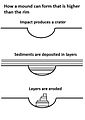 如圖所示,蓋爾撞擊坑的高山可能是從覆蓋了整個區域的沉積層被侵蝕後形成的。
 -

-

-
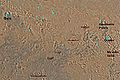 Aeolis區的地圖。蓋爾撞擊坑在該圖左上角。有大量成堆的岩石在蓋爾撞擊坑中間。
 -
 電腦生成的影像描繪火星的黑夜和白天交界處,包括蓋爾撞擊坑所在之處,正在開始接受晨光。


相關條目[編輯]
參考資料[編輯]
- ^ 1.0 1.1 Gale. Gazetteer of Planetary Nomenclature. IAU / USGS / NASA. [2018-11-20]. (原始內容存檔於2021-04-18).
- ^ NASA - NASA's Next Mars Rover to Land at Gale Crater. [2012-04-21]. (原始內容存檔於2020-05-11).
- ^ 3.0 3.1 3.2 3.3 Mars Odyssey Mission THEMIS: Feature Image: Gale Crater's History Book. [2011-07-27]. (原始內容存檔於2008-11-04).
- ^ Biography - Walter Frederick Gale - Australian Dictionary of Biography. [2012-04-21]. (原始內容存檔於2011-08-15).
- ^ 存档副本. [2018-09-12]. (原始內容存檔於2016-10-21).
- ^ NASA Staff. 'Mount Sharp' on Mars Compared to Three Big Mountains on Earth. NASA. 27 March 2012 [31 March 2012]. (原始內容存檔於2017-05-07).
- ^ Agle, D. C. 'Mount Sharp' On Mars Links Geology's Past and Future. NASA. 28 March 2012 [31 March 2012]. (原始內容存檔於2012-03-31).
- ^ Staff. NASA's New Mars Rover Will Explore Towering 'Mount Sharp'. Space.com. 29 March 2012 [30 March 2012]. (原始內容存檔於2012-03-30).
- ^ Cabrol et al. 1999. Hydrogeologic evolution of Gale Crater and its relevance in the exobiological exploration of Mars. Icarus: 139. 235-245.
- ^ Irwin et al. 2005. An intense terminal epoch of widespread fluvial activity on early Mars: 2. Increased runoff and palelake development. Journal of Geographical Research: 110. E12S15
- ^ Anderson and Bell, Geologic mapping and characterization of Gale Crater and implications for its potential as a Mars Science Laboratory landing site, Mars 5, 76-128, 2010, doi:10.1555/mars.2010.0004 (頁面存檔備份,存於網際網路檔案館)
- ^ Google Mars: Gale crater. [2012-04-22]. (原始內容存檔於2011-02-22).
- ^ 13.0 13.1 Google Mars: spacecraft. [2012-04-22]. (原始內容存檔於2011-02-22).
- ^ The Associated Press. NASA Launches Sophisticated Rover on Journey to Mars. The New York Times. 2011-11-26 [2011-11-26]. (原始內容存檔於2021-04-19).
- ^ Geometry Drives Selection Date for 2011 Mars Launch. News and Features. NASA/JPL-Caltech. [2011-07-27]. (原始內容存檔於2021-04-18).
- ^ Webster, Guy; Brown, Dwayne. NASA's Next Mars Rover To Land At Gale Crater. NASA JPL. 2011-07-22 [2011-07-22]. (原始內容存檔於2012-06-07).
- ^ Chow, Denise. NASA's Next Mars Rover to Land at Huge Gale Crater. Space.com. 2011-07-22 [2011-07-22]. (原始內容存檔於2019-10-25).
- ^ Amos, Jonathan. Mars rover aims for deep crater. BBC News. 2011-07-22 [2011-07-22]. (原始內容存檔於2011-07-22).
- ^ Mars landing sites down to final four. World News (WN) Network. [2012-04-16]. (原始內容存檔於2012-03-30).
外部連結[編輯]
| 維基共享資源上的相關多媒體資源:蓋爾撞擊坑 |
- Video (02:37) (07/21/2011) (頁面存檔備份,存於網際網路檔案館) - Gale Crater Landing Site For Mars Science Laboratory.
- Layers in Gale Crater (頁面存檔備份,存於網際網路檔案館)
- Central debris mound in Gale Crater (頁面存檔備份,存於網際網路檔案館)