
File:Argentina - Político 2.png

預覽大小:363 × 599 像素。 其他解析度:145 × 240 像素 | 568 × 937 像素。
原始檔案 (568 × 937 像素,檔案大小:25 KB,MIME 類型:image/png)
摘要
| 描述 |
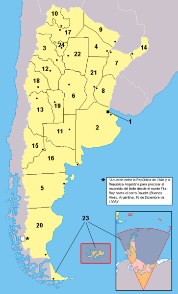
Español: Provincias de la Argentina. Los territorios en anaranjado no están bajo la soberanía argentina: se encuentran bajo la soberanía por el Reino Unido (ejemplo: Islas del Atlántico Sur) o es un reclamo en suspenso (ejemplo: Antártida)
English: Provinces of Argentina. Territories in orange are not under efective argentine soveregnity: they are either under british control, or in a suspended claim |
|||
| 日期 | ||||
| 來源 | Work based in the map at Image:Argentina - Político.png | |||
| 作者 | This map: Misionero and Gonzaloluengo. For the map this one is based over, check the link. | |||
| 其他版本 |
此檔案衍生的作品: Argentina.svg
|


Notas: 1: Ciudad de Buenos Aires (distrito federal)
2: Provincia de Buenos Aires
3: Catamarca
4: Chaco
5: Chubut
6: Córdoba
7: Corrientes
8: Entre Ríos
9: Formosa
10: Jujuy
11: La Pampa
12: La Rioja
13: Mendoza
14: Misiones
15: Neuquen
16: Rio Negro
17: Salta
18: San Juan
19: San Luis
20: Santa Cruz
21: Santa Fe
22: Santiago del Estero
23: Tierra del Fuego
24: Tucuman
授權條款
| 我,此作品的版權所有人,釋出此作品至公共領域。此授權條款在全世界均適用。 這可能在某些國家不合法,如果是的話: 我授予任何人有權利使用此作品於任何用途,除受法律約束外,不受任何限制。 |
檔案歷史
點選日期/時間以檢視該時間的檔案版本。
| 日期/時間 | 縮圖 | 尺寸 | 使用者 | 備註 | |
|---|---|---|---|---|---|
| 目前 | 2017年11月18日 (六) 18:09 | | 568 × 937(25 KB) | Janitoalevic | Better borders. |
| 2017年11月18日 (六) 18:06 |  | 568 × 937(25 KB) | Janitoalevic | . | |
| 2006年9月4日 (一) 17:31 |  | 568 × 937(61 KB) | Gonzaloluengo | ||
| 2006年4月23日 (日) 16:56 |  | 568 × 937(39 KB) | Misionero~commonswiki | Mapa editado de: Argentina - Político.png {{es|Mapa de las provincias de la República Argentina. Los territorios en anaranjado no están bajo la soberanía argentina: se encuentran ocupados por Inglaterra (Ej:Islas del Atlántico Sur) o es un reclamo e |
檔案用途
沒有使用此檔案的頁面。
全域檔案使用狀況
以下其他 wiki 使用了這個檔案:
- en.wikipedia.org 的使用狀況
- es.wikipedia.org 的使用狀況