
File:Beckton STP, Activated Sludge Tank - geograph.org.uk - 1481906.jpg
預覽大小:463 × 600 像素。 其他解析度:185 × 240 像素 | 494 × 640 像素。
原始檔案 (494 × 640 像素,檔案大小:167 KB,MIME 類型:image/jpeg)
摘要
| 描述 |
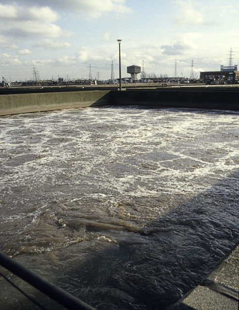
English: Beckton STP: Activated Sludge Tank The primary effluent from the settling tanks (1481890) is now largely free of solid matter, but contains much dissolved organic matter. In these tanks it is vigorously aerated so that micro-organisms can convert this to Carbon Dioxide and Water. From here the liquid goes to 1481916 to settle. The name 'Activated Sludge' refers to the fact that the tanks are seeded with the sludge from the previous generation of activation. See 1481923. |
| 日期 | |
| 來源 | From geograph.org.uk |
| 作者 | John Rostron |
| 姓名標示 (由许可协议要求) | John Rostron / Beckton STP: Activated Sludge Tank / |
| 拍攝地點 | | 位於此地的本圖片與其他圖片: OpenStreetMap |
|---|
_heading:45.00&language=zh-hant)
| 目標地點 | | 位於此地的本圖片與其他圖片: OpenStreetMap |
|---|
_heading:45.00&language=zh-hant)
授權條款

|
此檔案採用創用CC 姓名標示-相同方式分享 2.0 通用版授權條款。
姓名標示: John Rostron
- 您可以自由:
- 分享 – 複製、發佈和傳播本作品
- 重新修改 – 創作演繹作品
- 惟需遵照下列條件:
- 姓名標示 – 您必須指名出正確的製作者,和提供授權條款的連結,以及表示是否有對內容上做出變更。您可以用任何合理的方式來行動,但不得以任何方式表明授權條款是對您許可或是由您所使用。
- 相同方式分享 – 如果您利用本素材進行再混合、轉換或創作,您必須基於如同原先的相同或兼容的條款,來分布您的貢獻成品。
檔案歷史
點選日期/時間以檢視該時間的檔案版本。
| 日期/時間 | 縮圖 | 尺寸 | 使用者 | 備註 | |
|---|---|---|---|---|---|
| 目前 | 2011年3月2日 (三) 14:25 | | 494 × 640(167 KB) | GeographBot | == {{int:filedesc}} == {{Information |description={{en|1=Beckton STP: Activated Sludge Tank The primary effluent from the settling tanks (1481890) is now largely free of solid matter, but contains much dissolved organic matter. In these tanks it is vi |
檔案用途
下列頁面有用到此檔案:
全域檔案使用狀況
以下其他 wiki 使用了這個檔案:
- da.wikipedia.org 的使用狀況
- en.wikipedia.org 的使用狀況
- et.wikipedia.org 的使用狀況
- ga.wikipedia.org 的使用狀況