
File:Maricopa County Incorporated and Planning areas Glendale highlighted.svg

此 SVG 檔案的 PNG 預覽的大小:694 × 599 像素。 其他解析度:278 × 240 像素 | 556 × 480 像素 | 889 × 768 像素 | 1,185 × 1,024 像素 | 2,371 × 2,048 像素 | 940 × 812 像素。
原始檔案 (SVG 檔案,表面大小:940 × 812 像素,檔案大小:1.05 MB)
摘要
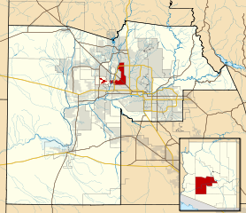
| 描述 | This map shows the incorporated areas and Indian reservation boundaries in Maricopa County, Arizona, along with water bodies and major highways and roads. Glendale is highlighted in red. Other incorporated cities are shown in gray, planning area borders for these cities and Indian reservation borders are shown as solid black lines. Changes from Previous Version: Updated the maps to include water bodies and to make "less boring" than the plain black/white/gray maps. Format was updated to match standards laid out by WikiProject Maps/Conventions. Map data is based on data from the following Webpage: Maricopa County Interactive GIS Map. I created this map in Inkscape. |
| 日期 | |
| 來源 | My own work, based on government information |
| 作者 | Ixnayonthetimmay |
| 授權許可 (重用此檔案) |
Public Domain |
| 其他版本 | See Category:Maps of Maricopa County for other versions of this image. |
授權條款
| 我,此作品的版權所有人,釋出此作品至公共領域。此授權條款在全世界均適用。 這可能在某些國家不合法,如果是的話: 我授予任何人有權利使用此作品於任何用途,除受法律約束外,不受任何限制。 |
檔案歷史
點選日期/時間以檢視該時間的檔案版本。
| 日期/時間 | 縮圖 | 尺寸 | 使用者 | 備註 | |
|---|---|---|---|---|---|
| 目前 | 2011年5月20日 (五) 06:32 | | 940 × 812(1.05 MB) | Ixnayonthetimmay | Uploading new version |
| 2008年8月30日 (六) 04:10 |  | 900 × 800(423 KB) | Ixnayonthetimmay | == Summary == {{Information |Description=This map shows the incorporated areas and unincorporated areas in Maricopa County, Arizona. [[:en:Glendale, Arizona| | |
| 2007年9月16日 (日) 00:16 |  | 900 × 800(384 KB) | Ixnayonthetimmay | {{Information |Description= |Source= |Date= |Author= |Permission= |other_versions= }} | |
| 2007年5月28日 (一) 10:00 |  | 900 × 780(329 KB) | Ixnayonthetimmay | ||
| 2007年5月22日 (二) 00:07 |  | 900 × 780(318 KB) | Ixnayonthetimmay | ||
| 2007年1月30日 (二) 05:05 |  | 904 × 758(189 KB) | Ixnayonthetimmay | {{Information |Description=This map shows the incorporated areas in Maricopa County, Arizona, highlighting Glendale in red. It also shows the boundaries for the |
檔案用途
沒有使用此檔案的頁面。
全域檔案使用狀況
以下其他 wiki 使用了這個檔案:
- ar.wikipedia.org 的使用狀況
- arz.wikipedia.org 的使用狀況
- br.wikipedia.org 的使用狀況
- ca.wikipedia.org 的使用狀況
- ceb.wikipedia.org 的使用狀況
- de.wikipedia.org 的使用狀況
- el.wikipedia.org 的使用狀況
- eo.wikipedia.org 的使用狀況
- es.wikipedia.org 的使用狀況
- eu.wikipedia.org 的使用狀況
- fa.wikipedia.org 的使用狀況
- fi.wikipedia.org 的使用狀況
- fr.wikipedia.org 的使用狀況
- ga.wikipedia.org 的使用狀況
- gl.wikipedia.org 的使用狀況
- hr.wikipedia.org 的使用狀況
- ht.wikipedia.org 的使用狀況
- hu.wikipedia.org 的使用狀況
- id.wikipedia.org 的使用狀況
- ja.wikipedia.org 的使用狀況
- kw.wikipedia.org 的使用狀況
- mrj.wikipedia.org 的使用狀況
- ms.wikipedia.org 的使用狀況
- pt.wikipedia.org 的使用狀況
- ro.wikipedia.org 的使用狀況
- sco.wikipedia.org 的使用狀況
- sr.wikipedia.org 的使用狀況
- sw.wikipedia.org 的使用狀況
- ta.wikipedia.org 的使用狀況
- tr.wikipedia.org 的使用狀況
- tt.wikipedia.org 的使用狀況
- ur.wikipedia.org 的使用狀況
- vi.wikipedia.org 的使用狀況
- vo.wikipedia.org 的使用狀況
- www.wikidata.org 的使用狀況