
File:1866 U.S. Coast Survey Nautical Chart of Map of New York City and Harbor - Geographicus - NewYorkCity3-uscs-1866.jpg

預覽大小:520 × 599 像素。 其他解析度:208 × 240 像素 | 417 × 480 像素 | 667 × 768 像素 | 889 × 1,024 像素 | 1,778 × 2,048 像素 | 5,209 × 6,000 像素。
原始檔案 (5,209 × 6,000 像素,檔案大小:7.11 MB,MIME 類型:image/jpeg)
摘要
| Coast Chart No. 20, New York Bay and Harbor, New York. | |||
|---|---|---|---|
| 作家 | |||
| 標題 |
Coast Chart No. 20, New York Bay and Harbor, New York. |
||
| 描述 |
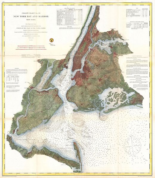
English: A rare 1866 coastal chart of New York City, it’s harbor, and environs. One of the first 19th century carts to depicts New York City as we know it today, including Manhattan, Queens, Brooklyn, the Bronx and Staten Island. Also includes Jersey City, Newark and Hoboken. This is possibly the most advanced chart in this series with far more detail than previous editions. In addition to inland details, this chart contains a wealth of practical information for the mariner from oceanic depths, to harbors and navigation tips on important channels. Map also includes tables of light houses and beacons, tides and magnetic declination as well as detailed sailing instructions. The triangulation for this chart was prepared by J. Ferguson and E. Blunt. The topography by H. L. Whiting, S. A. Gilbert, A. M Harrison, F. W. Door, C. Rockwell and J. M E. Chan. The hydrography was accomplished by R. Wainwright and T. A. Craven. The entire production was supervised by A. D. Bache, Superintendent of the Survey of the Coast of the United States and one of the most influential American cartographers of the 19th century. |
||
| 日期 | 1866年 (dated) | ||
| 尺寸 | 高度:31英寸(78.7釐米);寬度:27英寸(68.5釐米) | ||
| 登錄號 |
Geographicus link: NewYorkCity3-uscs-1866 |
||
| 來源/攝影者 |
Report of the Superintendant of the United States Coast Survey, Washington, (1867 Supplement to the 1865 edition).
|
||
授權條款
|
公有領域作品必須在美國以及來源國沒有版權問題,才能上傳至維基共享資源。如果此作品不是美國作品,這個文件必須要有一個額外的版權標記顯示此文件在來源國的版權狀態。
注意:此標籤不應用於錄音作品。 |
檔案歷史
點選日期/時間以檢視該時間的檔案版本。
| 日期/時間 | 縮圖 | 尺寸 | 用戶 | 備註 | |
|---|---|---|---|---|---|
| 目前 | 2011年3月23日 (三) 16:33 | | 5,209 × 6,000(7.11 MB) | BotMultichillT | {{subst:User:Multichill/Geographicus |link=http://www.geographicus.com/P/AntiqueMap/NewYorkCity3-uscs-1866 |product_name=1866 U.S. Coast Survey Nautical Chart of Map of New York City and Harbor |map_title=Coast Chart No. 20, New York Bay and Harbor, New Y |
檔案用途
下列頁面有用到此檔案:
全域檔案使用狀況
以下其他 wiki 使用了這個檔案:
- en.wikipedia.org 的使用狀況