
File:Puncak Jaya (NASA astronaut photograph).jpg

原始檔案 (1,280 × 764 像素,檔案大小:108 KB,MIME 類型:image/jpeg)
.jpg?uselang=zh-hk)
.jpg?uselang=zh-hk)
.jpg?action=history&uselang=zh-hk)
.jpg)
摘要
| 描述 |
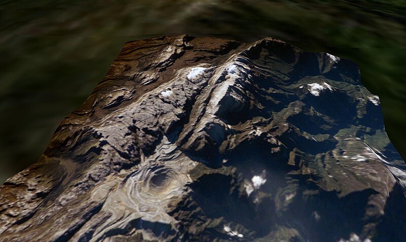
Puncak Jaya, West Papua, Indonesia. The Grasberg (Freeport) copper mine pit is in the foreground, and remnants of the Puncak Jaya glaciers behind. The summit of Puncak Jaya is at the far end of the central rib. Two remnants of the Northwall Firn are to the left of the peak. The Meren Glacier was in the valley between these and the peak, but disappeared sometime between 1994 and 2000[1]. The Carstenz Glacier is immediately right of the peak. (White patches further to the right are clouds, which appear to be on the terrain surface due to the image processing technique used.) At the current retreat rate, all these glaciers will be gone forever inside 10 years, making greater-Australia the first completely ice-free continent on the planet in 100,000 years. (Africa can't win. Kilimanjaro's ice is nearly gone, but there is still a fairly thick glacier left on Mount Kenya, and more in the Ruwenzori.)
worldwind://goto/world=Earth&lat=-4.06986&lon=137.14256&alt=8039&dir=90.3&tilt=52.2 (Imagery mostly cloudy - try Geocover 1990.) Also see |
| 日期 | 2006年六月10日 (原始上傳日期) |
| 來源 |
Made with NASA World Wind from NASA public domain imagery Originally from en.wikipedia; description page is/was here. |
| 作者 | Original uploader was Gergyl at en.wikipedia |
| 授權許可 (重用此檔案) |
Licensed under the GFDL by the author; Released under the GNU Free Documentation License. |
授權條款

|
已授權您依據自由軟體基金會發行的無固定段落、封面文字和封底文字GNU自由文件授權條款1.2版或任意後續版本,對本檔進行複製、傳播和/或修改。該協議的副本列在GNU自由文件授權條款中。 |
| 此檔案採用共享創意 姓名標示-相同方式分享 3.0 未在地化版本授權條款。 | ||
| 姓名標示: Gergyl at the English Wikipedia | ||
| ||
| 已新增授權條款標題至此檔案,作為GFDL授權更新的一部份。 |
原始上傳日誌
(All user names refer to en.wikipedia)
- 2006-06-10 09:38 Gergyl 1280×764×8 (110347 bytes)
- 2006-06-10 08:32 Gergyl 1280×764×8 (110462 bytes) Puncak Jaya, Indonesia. A June 2005 NASA astronaut photograph draped over the NASA World Wind SRTM90 DTM and viewed from a similar angle to the 1936 and 1972 USGS photos of this tropical glacier group. worldwind://goto/world=Earth&lat=-4.06651&lon=137.1
檔案歷史
點選日期/時間以檢視該時間的檔案版本。
| 日期/時間 | 縮圖 | 尺寸 | 用戶 | 備註 | |
|---|---|---|---|---|---|
| 目前 | 2007年4月26日 (四) 14:45 | | 1,280 × 764(108 KB) | Alfonso"~commonswiki | {{Information |Description=en:Puncak Jaya, en:West Papua, en:Indonesia. The Grasberg (Freeport) copper mine pit is in the foreground, and remnants of the Puncak Jaya glaciers behind. The summ |
檔案用途
下列頁面有用到此檔案:
全域檔案使用狀況
以下其他 wiki 使用了這個檔案:
- als.wikipedia.org 的使用狀況
- ast.wikipedia.org 的使用狀況
- az.wikipedia.org 的使用狀況
- be-tarask.wikipedia.org 的使用狀況
- be.wikipedia.org 的使用狀況
- ca.wikipedia.org 的使用狀況
- de.wikipedia.org 的使用狀況
- de.wikivoyage.org 的使用狀況
- en.wikipedia.org 的使用狀況
- eo.wikipedia.org 的使用狀況
- es.wikipedia.org 的使用狀況
- eu.wikipedia.org 的使用狀況
- fi.wikipedia.org 的使用狀況
- fr.wikipedia.org 的使用狀況
- hr.wikipedia.org 的使用狀況
- mt.wikipedia.org 的使用狀況
- ru.wikipedia.org 的使用狀況
- sh.wikipedia.org 的使用狀況
- sr.wikipedia.org 的使用狀況
- uk.wikipedia.org 的使用狀況
- vec.wikipedia.org 的使用狀況
.jpg)