
File:US insular areas.png

原始檔案 (1,482 × 624 像素,檔案大小:39 KB,MIME 類型:image/png)

|
File:US insular areas.svg是本檔案的向量版本。 如果品質不低,就應該優先使用該檔案,而非PNG檔案。
File:US insular areas.png → File:US insular areas.svg
更多資訊請參閱Help:SVG/zh。 |
 |
摘要
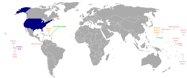
This is a map of the US Insular areas. The first version of this map was based off Image:BlankMap-World-v6.png by User:Astrokey44 with the locations of a few islands added; the source for this are two CIA maps; the maps are a map of the Pacific region and a map of the United States Pacific Island Wildlife Refuges. Hawaii has also been added to the map. Names of the islands are from the CIA Factbook. The second version is based off Image:Dependent_territories_2007.png by User:Sesmith. This map is color-coded according to each island's status:
For an uncolor-coded map, see Image:US_insular_areas-B.png. For a version with the freely associated states, see Image:US_insular_areas FAS.png.
The previous map is under the GFDL; because of this, this map is also.
授權條款

|
已授權您依據自由軟體基金會發行的無固定段落、封面文字和封底文字GNU自由文件授權條款1.2版或任意後續版本,對本檔進行複製、傳播和/或修改。該協議的副本列在GNU自由文件授權條款中。 |
| 此檔案採用共享創意 姓名標示-相同方式分享 3.0 未在地化版本授權條款。 | ||
| ||
| 已新增授權條款標題至此檔案,作為GFDL授權更新的一部份。 |
檔案歷史
點選日期/時間以檢視該時間的檔案版本。
| 日期/時間 | 縮圖 | 尺寸 | 用戶 | 備註 | |
|---|---|---|---|---|---|
| 目前 | 2014年8月2日 (六) 06:35 | | 1,482 × 624(39 KB) | KronosLine | Fix Ukraine, the Caucasus, and added South Sudan. |
| 2008年3月5日 (三) 04:52 |  | 1,482 × 624(52 KB) | Hoshie | rebuilt using User:Sesmith's maps; more to come. | |
| 2007年3月17日 (六) 10:38 |  | 1,482 × 624(32 KB) | Hoshie | This is a map of the US Insular areas. The base map is Image:BlankMap-World-v6.png by User:Astrokey44 with the locations of a few islands added; the source for this are two CIA maps; the maps are a [https://www.cia.gov/cia/publications/factbook/ |
檔案用途
沒有使用此檔案的頁面。
全域檔案使用狀況
以下其他 wiki 使用了這個檔案:
- ast.wikipedia.org 的使用狀況
- es.wikipedia.org 的使用狀況
- vi.wikipedia.org 的使用狀況
- www.wikidata.org 的使用狀況