
File:Vuiamor2.jpg
此為最大尺寸。
Vuiamor2.jpg (640 × 428 像素,檔案大小:136 KB,MIME 類型:image/jpeg)
摘要
| 描述 |
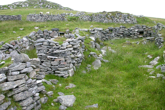
English: Ruined croft houses on w:Fuaigh Mòr. The remains of houses and sheep fanks on the deserted island. The island was cleared of its inhabitants in 1841, and is now only used for grazing sheep. w:Loch Roag.
Español: Casas de cría en ruinas en Fuaigh Mòr (isla del Reino Unido situada en Escocia). Esta zona de Fuaigh Mòr quedó deshabitada en 1841, y en la actualidad solamente es usada para pastorear ovejas.
|
||
| 日期 | |||
| 來源 |
|
||
| 作者 | Sarah Egan |

| 拍攝地點 | | 位於此地的本圖片與其他圖片: OpenStreetMap |
|---|
| 目標地點 | | 位於此地的本圖片與其他圖片: OpenStreetMap |
|---|
_region:GB-GBN_heading:270.00&language=zh-hk)
授權條款
此檔案採用共享創意 姓名標示-相同方式分享 2.0 通用版授權條款。
- 您可以自由:
- 分享 – 複製、發佈和傳播本作品
- 重新修改 – 創作演繹作品
- 惟需遵照下列條件:
- 姓名標示 – 您必須指名出正確的製作者,和提供授權條款的連結,以及表示是否有對內容上做出變更。您可以用任何合理的方式來行動,但不得以任何方式表明授權條款是對您許可或是由您所使用。
- 相同方式分享 – 如果您利用本素材進行再混合、轉換或創作,您必須基於如同原先的相同或兼容的條款,來分布您的貢獻成品。
檔案歷史
點選日期/時間以檢視該時間的檔案版本。
| 日期/時間 | 縮圖 | 尺寸 | 用戶 | 備註 | |
|---|---|---|---|---|---|
| 目前 | 2008年7月7日 (一) 13:12 | | 640 × 428(136 KB) | MacRusgail | == Summary == {{Information| |Description=Ruined croft houses on w:Fuaigh Mòr. The remains of houses and sheep fanks on the deserted island. The island was cleared of its inhabitants in 1841 and is now only used for grazing sheep. w:Loch Roag. |S |
檔案用途
全域檔案使用狀況
以下其他 wiki 使用了這個檔案:
- az.wikipedia.org 的使用狀況
- cs.wikipedia.org 的使用狀況
- cy.wikipedia.org 的使用狀況
- da.wikipedia.org 的使用狀況
- de.wikipedia.org 的使用狀況
- en.wikipedia.org 的使用狀況
- es.wikipedia.org 的使用狀況
- eu.wikipedia.org 的使用狀況
- fi.wikipedia.org 的使用狀況
- ga.wikipedia.org 的使用狀況
- gd.wikipedia.org 的使用狀況
- gl.wikipedia.org 的使用狀況
- he.wikipedia.org 的使用狀況
- hr.wikipedia.org 的使用狀況
- it.wikipedia.org 的使用狀況
- ja.wikipedia.org 的使用狀況
- nn.wikipedia.org 的使用狀況
- ru.wikipedia.org 的使用狀況
- sco.wikipedia.org 的使用狀況
- sh.wikipedia.org 的使用狀況
- sv.wikipedia.org 的使用狀況
- uk.wikipedia.org 的使用狀況
- www.wikidata.org 的使用狀況