| 來源 |
自己的作品
- [1] I territori di Tuscania, Norchia, Marta, Viterbo, Ferento, Bagnoregio, Orvieto e Savana, interessati dal nostro studio sulle murature, oltre ai centri più settentrionali di Rosellae e Populonia, venivano annessi nel 787 al Patrimonio di San Pietro.
- [2] Adriano ricevette la promessa di altri miglioramenti territorali, che però furono concessi formalmente solo nel 787, quando Carlo gli aggiuducò la Toscana meridionale (Viterbo, Orvieto, Soana) con le città maritime di Grosseto (Rosellae) e di Piombino (Populonia).
- [3] After the long paragraph in de Ludovicianum that bgins with Ravenna and ends with Sabina, we read a clause that says, "Likewise in Lombard Tuscny Città di Castello, Orvieto, Bagnorea, Farentum, Viterbo, Orchia, Marta, Toscanella, Sovana, Populonia, Rosellae [Groseto]. Lindner and Gundlach thought that this passage must date from 781, but most scholars have placed it in 787. [4]: The duchy of Rome had never extended into Lombard Tuscany, and in 781 the precise northern frontir of the duchy itself was fixed and defined at its ancient limits in suburbicarian, or Roman Tuscany. Then Charlemagne added to the Republic a section of southern and coastal Lombard Tuscany which he detached from the regnum. It seems, again, that Hadrian was being compensated for the fact that the Quierzy-Rome promise was not literally fulfilled. The Republic received lands it had never held in return for abandonig claims that Charlemagne could no honor.
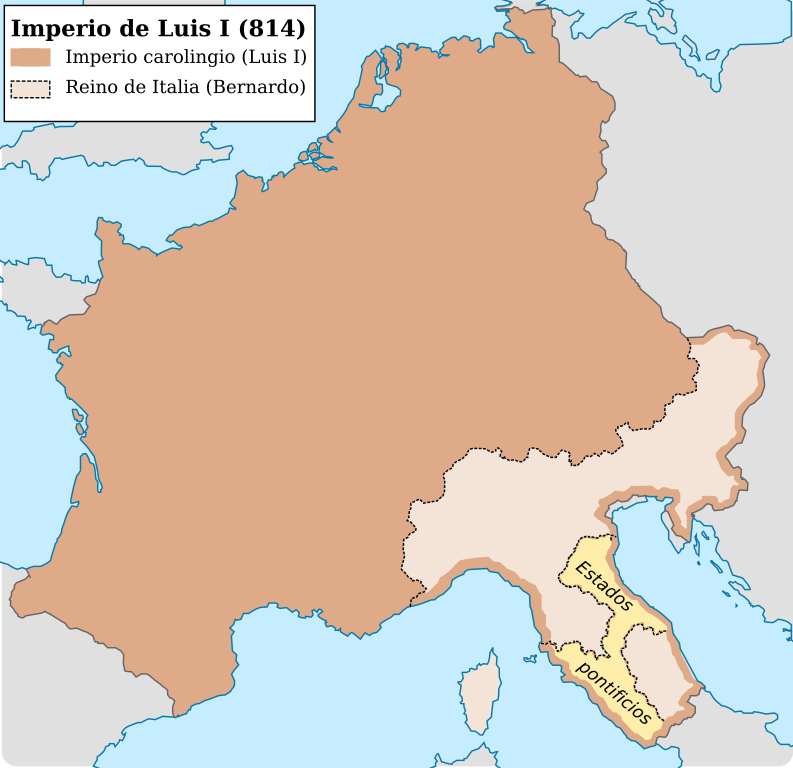
- [5]: The 817 treaty is the first well-authenticated document to define the temporal power of the of the popes and their relations with the Frankish monarchy. Although it lists places and areas, and does not try to mark off a frontier for the Papal State, we know from the 'division of the kingdom' of 806 that a frontier was consdered to exist. The frontier of 817 reflects the cutting down by Charlemagne of Hadrian's original ambitious claims. It ran from the Tyrrhenian coast at Massa Marittima (Populonia) and Rosella of Lake Orbetello and inland south of Lake Trasimene, thus including a large part of Lombard Tuscany, but running far south of the early Roman claims. It included the Via Amerina, which skirted the important castle of Gallese, and went though Amelia to Perugia to rejoin the Via Flaminia by way of Gubbio, at Scheggia. This was 'Roman' corridor across the Apennines through Fossombrone and Urbino in order to communicate with the exarchate of Ravenna, which with Pentapolis is again assigned to papal jurisdiction. The pact says explicitly that this jurisdiction is to be the same as that exercised by the pope in Rome and its duchy. Near Rome, the grant of the small mountain area of Sabina and Riet was maintained: this was the only part of Charlemagne's grant of the duchy of Spoleto actually assigned to the popes. Apart from this they ruled 'Campagna' as far south as the river Garigliano.
- [6] A further landmark was the pactum which, in 817, the Emperor Louis the Pious made which Pope Paschal I, a text of which survives. Although much interpolated, it envisaged a more southerly limit to the papal lands, running approximately from Populonia to Orvieto and Perigia, and hence northwards to include Bologna and Ferrara; it finally followed the River Adige to the sea. Of the duchy of Spoleto, only Sabina remained to the papacy, but lands near Naples and Salerno were added, as, lmost certainly, were the islands of Sardinia and Sicily.
|


