
File:NUTS 1 statistical regions of the United Kingdom map.svg

此 SVG 檔案的 PNG 預覽的大小:405 × 599 像素。 其他解析度:162 × 240 像素 | 324 × 480 像素 | 519 × 768 像素 | 692 × 1,024 像素 | 1,384 × 2,048 像素 | 871 × 1,289 像素。
原始檔案 (SVG 檔案,表面大小:871 × 1,289 像素,檔案大小:2.43 MB)
摘要
| 描述 |
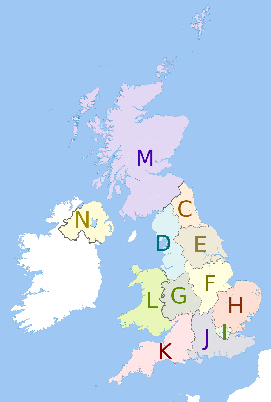
English: Map showing the NUTS 1 statistical regions of the United Kingdom in 2011.
Equirectangular map projection on WGS 84 datum, with N/S stretched 170% Geographic limits:
The region colours are paler versions of those in en:File:United Kingdom NUTS 1.png.
|
| 日期 | (UTC) |
| 來源 |
本檔案衍生自: United Kingdom police areas map.svg:  |
| 作者 |
|
| 這是一張修飾過的圖片,即本圖片是用軟體修改過後的版本,修改的方式或內容有:recoloured with some boundary lines hidden。原版圖片來源:United Kingdom police areas map.svg。修改者:Dr Greg。
|
授權條款
我,本作品的著作權持有者,決定用以下授權條款發佈本作品:
此檔案採用共享創意 姓名標示-相同方式分享 3.0 未在地化版本授權條款。
姓名標示: Dr Greg and Nilfanion. Contains Ordnance Survey data © Crown copyright and database right 2011
- 您可以自由:
- 分享 – 複製、發佈和傳播本作品
- 重新修改 – 創作演繹作品
- 惟需遵照下列條件:
- 姓名標示 – 您必須指名出正確的製作者,和提供授權條款的連結,以及表示是否有對內容上做出變更。您可以用任何合理的方式來行動,但不得以任何方式表明授權條款是對您許可或是由您所使用。
- 相同方式分享 – 如果您利用本素材進行再混合、轉換或創作,您必須基於如同原先的相同或兼容的條款,來分布您的貢獻成品。
原始上傳日誌
This image is a derivative work of the following images:
- File:United_Kingdom_police_areas_map.svg licensed with Cc-by-sa-3.0
- 2011-10-12T11:33:39Z Nilfanion 871x1289 (2511111 Bytes) {{Information |Description=Map showing the [[w:Police areas|Police areas]] of the United Kingdom in 2011. Equirectangular map projection on WGS 84 datum, with N/S stretched 170% Geographic limits: *West: 11.0W *East: 2.2E *
Uploaded with derivativeFX
檔案歷史
點選日期/時間以檢視該時間的檔案版本。
| 日期/時間 | 縮圖 | 尺寸 | 用戶 | 備註 | |
|---|---|---|---|---|---|
| 目前 | 2012年5月12日 (六) 13:27 | | 871 × 1,289(2.43 MB) | Dr Greg | == {{int:filedesc}} == {{Information |Description={{en|Map showing the NUTS 1 statistical regions of the United Kingdom in 2011. Equirectangular map projection on WGS 84 datum, with N/S stretched 170% Geographic l... |
檔案用途
下列頁面有用到此檔案:
全域檔案使用狀況
以下其他 wiki 使用了這個檔案:
- bs.wikipedia.org 的使用狀況
- de.wikipedia.org 的使用狀況
- en.wikipedia.org 的使用狀況
- fi.wikipedia.org 的使用狀況
- it.wikipedia.org 的使用狀況
- pt.wikipedia.org 的使用狀況