
File:Peace-Athabasca Delta.JPG

預覽大小:538 × 600 像素。 其他解析度:215 × 240 像素 | 430 × 480 像素 | 825 × 920 像素。
原始檔案 (825 × 920 像素,檔案大小:678 KB,MIME 類型:image/jpeg)
摘要
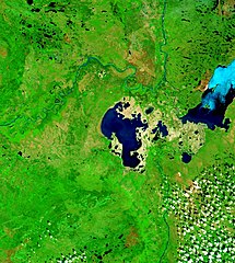
| 描述 | Peace-Athabasca Delta with Lake Claire and mouths of Peace River and Athabasca River. |
| 日期 | Visualization Date: 2002-09-21 |
| 來源 | Visible Earth, NASA |
| 作者 | Jacques Descloitres, MODIS Land Rapid Response Team, NASA/GSFC |
| 授權許可 (重用此檔案) |
PD |
Cropped from the original 4800 x 3600 JPEG (4.4MB) image.
授權條款
| 本作品由NASA創作,屬於公有領域。根據NASA的版權政策:“NASA的創作除非另有聲明否則不受版權保護。”(參見:Template:PD-USGov/zh,NASA版權政策或JPL圖像使用政策) | ||
 |
警告:
|
檔案歷史
點選日期/時間以檢視該時間的檔案版本。
| 日期/時間 | 縮圖 | 尺寸 | 用戶 | 備註 | |
|---|---|---|---|---|---|
| 目前 | 2006年9月21日 (四) 14:28 | | 825 × 920(678 KB) | Qyd | {{Information |Description= Peace-Athabasca Delta with Lake Claire and mouths of Pecae River and Athabasca River. |Source= [http://visibleearth.nasa.gov/view_rec.php?id=6233 Visible Earth, NASA] |Date= Visualization Date: 2002-09-21 |Author= Jacques Des |
檔案用途
下列頁面有用到此檔案:
全域檔案使用狀況
以下其他 wiki 使用了這個檔案:
- bg.wikipedia.org 的使用狀況
- ca.wikipedia.org 的使用狀況
- ceb.wikipedia.org 的使用狀況
- cv.wikipedia.org 的使用狀況
- de.wikipedia.org 的使用狀況
- en.wikipedia.org 的使用狀況
- es.wikipedia.org 的使用狀況
- fr.wikipedia.org 的使用狀況
- hr.wikipedia.org 的使用狀況
- it.wikipedia.org 的使用狀況
- ja.wikipedia.org 的使用狀況
- lv.wikipedia.org 的使用狀況
- nl.wikipedia.org 的使用狀況
- pl.wikipedia.org 的使用狀況
- pt.wikipedia.org 的使用狀況
- ru.wikipedia.org 的使用狀況
- sr.wikipedia.org 的使用狀況
- sv.wikipedia.org 的使用狀況