
File:Whitehall sketch map Chinese.png

預覽大小:410 × 600 像素。 其他解析度:164 × 240 像素 | 503 × 736 像素。
原始檔案 (503 × 736 像素,檔案大小:137 KB,MIME 類型:image/png)
摘要
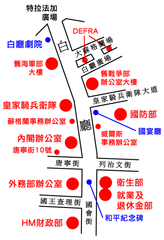
| 描述 | Outline map of Whitehall, London, showing the position of the major UK Government buildings there. |
| 日期 | |
| 來源 | GFDL image on English Wikipedia |
| 作者 | Original image by ChrisO / Translate & Upload by Mike |
| 其他版本 | English version |
授權條款
我,本作品的著作權持有者,決定用以下授權條款發佈本作品:

|
已授權您依據自由軟體基金會發行的無固定段落、封面文字和封底文字GNU自由文件授權條款1.2版或任意後續版本,對本檔進行複製、傳播和/或修改。該協議的副本列在GNU自由文件授權條款中。 |
| 此檔案採用共享創意 姓名標示-相同方式分享 3.0 未在地化版本授權條款。 | ||
| ||
| 已新增授權條款標題至此檔案,作為GFDL授權更新的一部份。 |
您可以選擇您需要的授權條款。
檔案歷史
點選日期/時間以檢視該時間的檔案版本。
| 日期/時間 | 縮圖 | 尺寸 | 用戶 | 備註 | |
|---|---|---|---|---|---|
| 目前 | 2007年4月14日 (六) 02:37 | | 503 × 736(137 KB) | Mikepanhu | {{Information |Description= Outline map of Whitehall, London, showing the position of the major UK Government buildings there. |Source= [http://en.wikipedia.org/wiki/Image:Whitehall_sketch_map.png Public domain image on English Wikipedia] |Date=Apr 14, 20 |
檔案用途
下列頁面有用到此檔案: