
File:1755 Lisbon Earthquake Location.png
此為最大尺寸。
1755_Lisbon_Earthquake_Location.png (331 × 420 像素,檔案大小:100 KB,MIME 類型:image/png)
摘要
| 描述 |
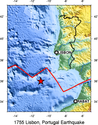
English: A map from the USGS showing the location of the 1755 Lisbon earthquake |
| 來源 | USGS http://neic.usgs.gov/neis/eq_depot/world/1755_11_01_loc.gif archived at https://web.archive.org/web/20061124075317/http://neic.usgs.gov/neis/eq_depot/world/1755_11_01_loc.gif |
| 作者 | USGS |
| 其他版本 |
Derivative works of this file: 1755 Lisbon Earthquake Location no cap.jpg - |
授權條款
|
|
原始上傳日誌
| 日期/時間 | 尺寸 | 使用者 | 備註 |
|---|---|---|---|
| 2005年7月17日, 11:45:20 | 331 × 420 (95089 bytes) | Stepanovas (留言 · 貢獻) | A map from the USGS showing the location of the 1755 Lisbon earthquake. http://neic.usgs.gov/neis/eq_depot/world/1755_11_01_loc.gif {{PD-USGov-Interior-USGS}} |
檔案歷史
點選日期/時間以檢視該時間的檔案版本。
| 日期/時間 | 縮圖 | 尺寸 | 使用者 | 備註 | |
|---|---|---|---|---|---|
| 目前 | 2014年7月12日 (六) 16:25 | | 331 × 420(100 KB) | GifTagger | Bot: Converting file to superior PNG file. (Source: 1755_Lisbon_Earthquake_Location.gif). This GIF was problematic due to transparency and non-greyscale color table. |
檔案用途
下列頁面有用到此檔案:
全域檔案使用狀況
以下其他 wiki 使用了這個檔案:
- ar.wikipedia.org 的使用狀況
- ast.wikipedia.org 的使用狀況
- az.wikipedia.org 的使用狀況
- be.wikipedia.org 的使用狀況
- bg.wikipedia.org 的使用狀況
- ca.wikipedia.org 的使用狀況
- da.wikipedia.org 的使用狀況
- de.wikipedia.org 的使用狀況
- en.wikipedia.org 的使用狀況
- eo.wikipedia.org 的使用狀況
- eu.wikipedia.org 的使用狀況
- fa.wikipedia.org 的使用狀況
- fi.wikipedia.org 的使用狀況
- fr.wikipedia.org 的使用狀況
- ga.wikipedia.org 的使用狀況
- he.wikipedia.org 的使用狀況
- hr.wikipedia.org 的使用狀況
- hu.wikipedia.org 的使用狀況
- hy.wikipedia.org 的使用狀況
- id.wikipedia.org 的使用狀況
- it.wikipedia.org 的使用狀況
- ja.wikipedia.org 的使用狀況
- ml.wikipedia.org 的使用狀況
- nl.wikipedia.org 的使用狀況
- pl.wikipedia.org 的使用狀況
- pt.wikipedia.org 的使用狀況
- ro.wikipedia.org 的使用狀況
- ru.wikipedia.org 的使用狀況
- sh.wikipedia.org 的使用狀況
- simple.wikipedia.org 的使用狀況
- sk.wikipedia.org 的使用狀況
- sl.wikipedia.org 的使用狀況
- th.wikipedia.org 的使用狀況
- tr.wikipedia.org 的使用狀況
- uk.wikipedia.org 的使用狀況
- vi.wikipedia.org 的使用狀況
- www.wikidata.org 的使用狀況
- zh-yue.wikipedia.org 的使用狀況