
File:Anenii Noi county.gif
此為最大尺寸。
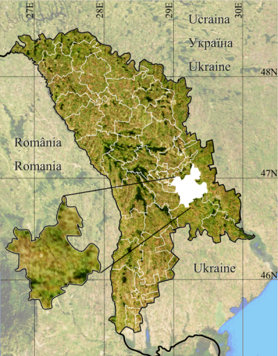
Anenii_Noi_county.gif (400 × 513 像素,檔案大小:854 KB,MIME 類型:image/gif、循環、18 畫格、2.8秒)
摘要
| 描述 |
Română: Anenii Noi county.
|
| 日期 | |
| 來源 | Topographic data SRTM from NASA and World Imagery & 3DEM & Inkscape |
| 作者 | Asybaris01 |
| 其他版本 |
|


授權條款
| 本作品由NASA創作,屬於公有領域。根據NASA的版權政策:“NASA的創作除非另有聲明否則不受版權保護。”(參見:Template:PD-USGov/zh,NASA版權政策或JPL圖像使用政策) | ||
 |
警告:
|
檔案歷史
點選日期/時間以檢視該時間的檔案版本。
| 日期/時間 | 縮圖 | 尺寸 | 使用者 | 備註 | |
|---|---|---|---|---|---|
| 目前 | 2012年1月19日 (四) 20:13 | | 400 × 513(854 KB) | Asybaris01 | {{Information |Description ={{ro|1=Anenii Noi county.}} |Source =Topographic data SRTM from NASA and World Imagery & 3DEM & Inkscape |Author =Asybaris01 |Date =jan 2012 |Permission = |other_versions = } |
檔案用途
沒有使用此檔案的頁面。
全域檔案使用狀況
以下其他 wiki 使用了這個檔案:
- ceb.wikipedia.org 的使用狀況
- en.wikipedia.org 的使用狀況
- fr.wikipedia.org 的使用狀況
- it.wikipedia.org 的使用狀況
- ka.wikipedia.org 的使用狀況
- nl.wikipedia.org 的使用狀況
- no.wikipedia.org 的使用狀況
- pl.wikipedia.org 的使用狀況
- pt.wikipedia.org 的使用狀況
- sk.wikipedia.org 的使用狀況
- sv.wikipedia.org 的使用狀況
- ur.wikipedia.org 的使用狀況
- www.wikidata.org 的使用狀況