
File:China, 742.svg

此 SVG 檔案的 PNG 預覽的大小:705 × 599 像素。 其他解析度:282 × 240 像素 | 565 × 480 像素 | 904 × 768 像素 | 1,205 × 1,024 像素 | 2,409 × 2,048 像素 | 1,000 × 850 像素。
原始檔案 (SVG 檔案,表面大小:1,000 × 850 像素,檔案大小:168 KB)
摘要
| 描述 |
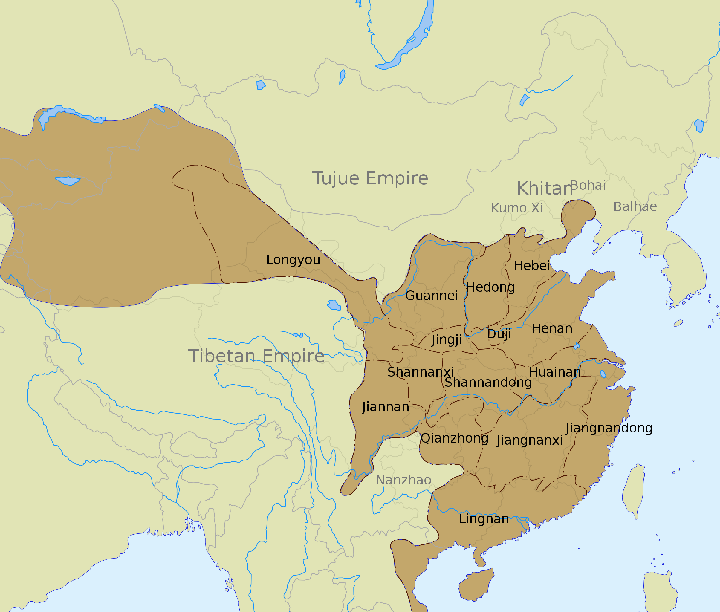
English: The Tang dynasty territory and inspection circuits (道 dào) in 742, according to the Cambridge History of China. |
| 日期 | |
| 來源 |
See also:
|
| 作者 | Yug |
| 其他版本 |
Derivative works of this file: |
| SVG開發 |
授權條款
我,本作品的著作權持有者,決定用以下授權條款發佈本作品:
此檔案採用創用CC 姓名標示-相同方式分享 3.0 未在地化版本授權條款。
- 您可以自由:
- 分享 – 複製、發佈和傳播本作品
- 重新修改 – 創作演繹作品
- 惟需遵照下列條件:
- 姓名標示 – 您必須指名出正確的製作者,和提供授權條款的連結,以及表示是否有對內容上做出變更。您可以用任何合理的方式來行動,但不得以任何方式表明授權條款是對您許可或是由您所使用。
- 相同方式分享 – 如果您利用本素材進行再混合、轉換或創作,您必須基於如同原先的相同或兼容的條款,來分布您的貢獻成品。
檔案歷史
點選日期/時間以檢視該時間的檔案版本。
| 日期/時間 | 縮圖 | 尺寸 | 使用者 | 備註 | |
|---|---|---|---|---|---|
| 目前 | 2020年3月12日 (四) 01:45 | | 1,000 × 850(168 KB) | Jonteemil | Fake SVG Reverted to version as of 17:36, 16 December 2012 (UTC) |
| 2019年1月14日 (一) 06:10 |  | 1,000 × 850(278 KB) | 复旦大学张超 | Bohai and Balhae are the same | |
| 2012年12月16日 (日) 17:36 |  | 1,000 × 850(168 KB) | Kanguole | Revise western extent of civil administration per Cambridge History | |
| 2008年5月30日 (五) 04:40 |  | 1,000 × 850(221 KB) | Yug | Correction for the eastern area, according to a newly find sources. | |
| 2008年5月29日 (四) 05:04 |  | 1,000 × 850(221 KB) | Yug | ||
| 2008年5月28日 (三) 18:56 |  | 1,000 × 850(218 KB) | Yug | {{Information |Description={{en|1=The Tang dynasty territory and provinces in 742, according to the Cambridge History of China.<br />NB: The Western area was not depict by my source, accordingly, this area (Longyou province, 隴右) is show by a blur area |
檔案用途
沒有使用此檔案的頁面。
全域檔案使用狀況
以下其他 wiki 使用了這個檔案:
- azb.wikipedia.org 的使用狀況
- bo.wikipedia.org 的使用狀況
- ca.wikipedia.org 的使用狀況
- ce.wikipedia.org 的使用狀況
- de.wikipedia.org 的使用狀況
- en.wikipedia.org 的使用狀況
- History of China
- Tang dynasty
- Talk:Tang dynasty
- Han Chinese
- History of the Khitans
- Circuit (administrative division)
- An Lushan
- Emperor Xuanzong of Tang
- Wikipedia:Graphics Lab/Images to improve/Archive/Jul 2008
- User talk:PericlesofAthens/Archive 5
- Jiangnanxi Circuit
- Jiangnan Circuit
- Administrative divisions of the Tang dynasty
- User:Falcaorib
- Administration of territory in dynastic China
- fa.wikipedia.org 的使用狀況
- fr.wikipedia.org 的使用狀況
- hak.wikipedia.org 的使用狀況
- id.wikipedia.org 的使用狀況
- lt.wikipedia.org 的使用狀況
- nl.wikipedia.org 的使用狀況
- no.wikipedia.org 的使用狀況
- ru.wikipedia.org 的使用狀況
- tr.wikipedia.org 的使用狀況
- uk.wikipedia.org 的使用狀況
- uz.wikipedia.org 的使用狀況
- vi.wikipedia.org 的使用狀況
- www.wikidata.org 的使用狀況
檢視此檔案的更多全域使用狀況。