
File:Droysen - Oströmisches Reich.jpg
預覽大小:800 × 529 像素。 其他解析度:320 × 212 像素 | 640 × 423 像素 | 1,024 × 677 像素 | 1,280 × 846 像素 | 3,025 × 2,000 像素。
原始檔案 (3,025 × 2,000 像素,檔案大小:1.09 MB,MIME 類型:image/jpeg)
摘要
| 描述 |
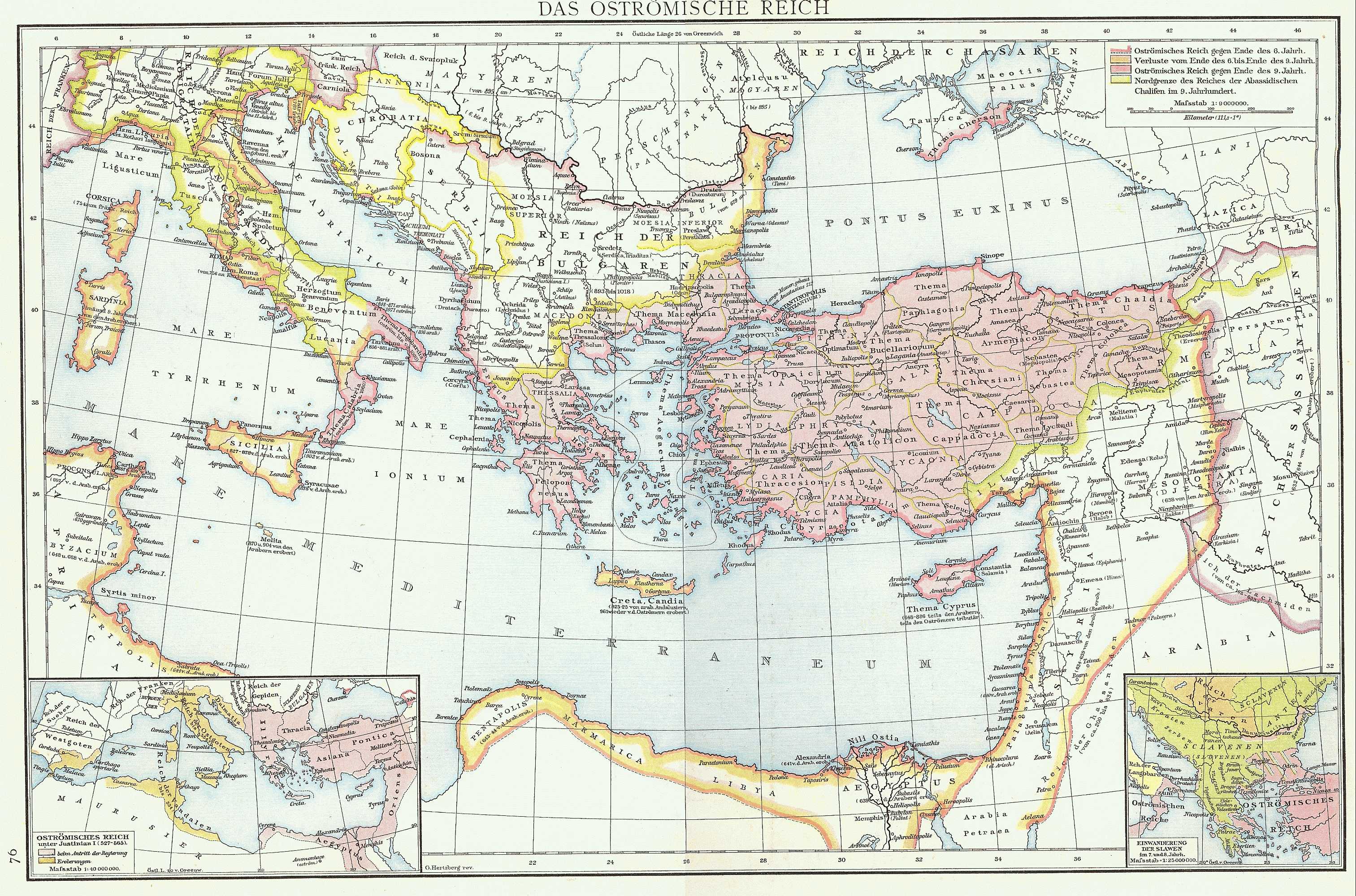
English: Map of the Byzantine Empire taken from G. Droysens Allgemeiner Historischer Handatlas, Verlag Velhagen und Klasing 1886
Deutsch: Karte des Byzantinischen (Oströmischen) Reiches aus G. Droysens Allgemeiner Historischer Handatlas, Verlag Velhagen und Klasing 1886 |
| 日期 | |
| 來源 | G. Droysens Allgemeiner Historischer Handatlas, Verlag Velhagen und Klasing, Bielefeld / Leipzig 1886 |
| 作者 | Professor Gustav Droysen (Hg.), Professor G. Hertzberg (Zeichnung) |
授權條款
|
本作品在其來源國以及其他著作權期限是作者逝世後70年或以下的國家與地區屬於公有領域。
| |
| 此作品無已知的著作權限制,亦不受所有相關和鄰接的權利限制。 | |
檔案歷史
點選日期/時間以檢視該時間的檔案版本。
| 日期/時間 | 縮圖 | 尺寸 | 使用者 | 備註 | |
|---|---|---|---|---|---|
| 目前 | 2022年11月16日 (三) 16:16 | | 3,025 × 2,000(1.09 MB) | Gyalu22 | Reverted to version as of 10:14, 10 July 2009 (UTC) |
| 2016年9月20日 (二) 14:46 |  | 3,025 × 2,000(2.31 MB) | Julieta39 | Better contrast | |
| 2009年7月10日 (五) 10:14 |  | 3,025 × 2,000(1.09 MB) | Nikephoros | {{Information |Description={{en|1=Map of the Byzantine Empire taken from ''G. Droysens Allgemeiner Historischer Handatlas'', Verlag Velhagen und Klasing 1886}} {{de|1=Karte des Byzantinischen (Oströmischen) Reiches aus ''G. Droysens Allgemeiner Historisc |
檔案用途
下列頁面有用到此檔案:
全域檔案使用狀況
以下其他 wiki 使用了這個檔案:
- als.wikipedia.org 的使用狀況
- ar.wikipedia.org 的使用狀況
- de.wikipedia.org 的使用狀況
- en.wikipedia.org 的使用狀況
- es.wikipedia.org 的使用狀況
- fr.wikipedia.org 的使用狀況
- he.wikipedia.org 的使用狀況
- id.wikipedia.org 的使用狀況
- it.wikipedia.org 的使用狀況
- la.wikipedia.org 的使用狀況
- mk.wikipedia.org 的使用狀況
- nl.wikipedia.org 的使用狀況
- pt.wikipedia.org 的使用狀況
- ro.wikipedia.org 的使用狀況
- ru.wikipedia.org 的使用狀況
- tr.wikipedia.org 的使用狀況
- uk.wikipedia.org 的使用狀況