
File:Rif Dimashq offensive (March 2013).svg

此 SVG 檔案的 PNG 預覽的大小:800 × 523 像素。 其他解析度:320 × 209 像素 | 640 × 419 像素 | 1,024 × 670 像素 | 1,280 × 837 像素 | 2,560 × 1,674 像素 | 1,856 × 1,214 像素。
原始檔案 (SVG 檔案,表面大小:1,856 × 1,214 像素,檔案大小:13.07 MB)
.svg?uselang=zh-tw)
.svg?uselang=zh-tw)
.svg?action=history&uselang=zh-tw)
.svg)
摘要
| 描述 |
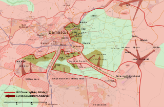
English: Map of the March 2013 Rif Dimashq offensive, showing frontlines before the offensive, and the current strategic situation.
العربية: خريطة تظهر هجوم مارس 2013 على دمشق، تظهر الخريطة خطوط الجبهات قبل الهجوم، و الوضع الاستراتيجي منذ سبتمبر 2013. |
| 日期 | |
| 來源 | 自己的作品, OpenStreetMap |
| 作者 | MrPenguin20 |
授權條款
| This work contains information from OpenStreetMap, which is made available under the Open Database License (ODbL).
The ODbL does not require any particular license for maps produced from ODbL data. Prior to 1 August 2020, map tiles produced by the OpenStreetMap Foundation were licensed under the CC-BY-SA-2.0 license. Maps produced by other people may be subject to other licences. |
我,本作品的著作權持有者,決定用以下授權條款發佈本作品:
此檔案採用創用CC 姓名標示-相同方式分享 3.0 未在地化版本授權條款。
- 您可以自由:
- 分享 – 複製、發佈和傳播本作品
- 重新修改 – 創作演繹作品
- 惟需遵照下列條件:
- 姓名標示 – 您必須指名出正確的製作者,和提供授權條款的連結,以及表示是否有對內容上做出變更。您可以用任何合理的方式來行動,但不得以任何方式表明授權條款是對您許可或是由您所使用。
- 相同方式分享 – 如果您利用本素材進行再混合、轉換或創作,您必須基於如同原先的相同或兼容的條款,來分布您的貢獻成品。
檔案歷史
點選日期/時間以檢視該時間的檔案版本。
.svg&variant=zh-tw&dir=prev)
.svg&variant=zh-tw&offset=20130903001601)
.svg&variant=zh-tw&offset=&limit=20)
.svg&variant=zh-tw&offset=&limit=50)
.svg&variant=zh-tw&offset=&limit=100)
.svg&variant=zh-tw&offset=&limit=250)
.svg&variant=zh-tw&offset=&limit=500)
| 日期/時間 | 縮圖 | 尺寸 | 使用者 | 備註 | |
|---|---|---|---|---|---|
| 目前 | 2018年8月6日 (一) 17:27 | | 1,856 × 1,214(13.07 MB) | Rr016 | Filled in empty spaces, as per AlAboud83's request |
| 2013年12月7日 (六) 16:55 |  | 1,856 × 1,214(13.06 MB) | EkoGraf | This map is for the offensive that lasted until late August. A map for the development of the offensive that started in September already exists | |
| 2013年11月13日 (三) 19:04 |  | 1,485 × 971(11.56 MB) | U5K0 | hejeira to loyalists per enwp | |
| 2013年11月7日 (四) 21:57 |  | 1,485 × 971(11.56 MB) | U5K0 | Al-Sabinah to loyalists per enwp article | |
| 2013年10月26日 (六) 09:57 |  | 1,485 × 971(11.56 MB) | U5K0 | Hatetat al-Turkman per english wp article | |
| 2013年10月9日 (三) 17:37 |  | 1,485 × 971(10.4 MB) | Ahmadac~commonswiki | Updated map based on https://en.wikipedia.org/wiki/Template:Syrian_civil_war_detailed_map - Also added Husseiniyah under SAA control. http://www.al-akhbar.com/node/192916 | |
| 2013年9月23日 (一) 00:12 |  | 1,856 × 1,214(13.06 MB) | MrPenguin20 | Uploaded correct version. | |
| 2013年9月23日 (一) 00:06 |  | 1,856 × 1,214(13.06 MB) | MrPenguin20 | Marked several military bases. Marked Sheba'a. Daraya contested. | |
| 2013年9月15日 (日) 13:34 |  | 1,856 × 1,214(9.33 MB) | MrPenguin20 | The M5 highway under the control of SAA before the attack. M1 also under government control. Al-Sabinah, Hujayrah, Deir Salman, Yalda, Babbila and Beit sahem are contested. Hatitat al-Turkuman and Deir al-Asafir under attack from SAA. Qadam also cont... | |
| 2013年9月3日 (二) 00:16 |  | 1,856 × 1,214(9.36 MB) | MrPenguin20 | Jamraya & surrounding area under government control according to [https://www.facebook.com/photo.php?fbid=575156802521211&set=a.224155897621305.50803.217139528322942&type=1 new map]. |
檔案用途
下列頁面有用到此檔案:
全域檔案使用狀況
以下其他 wiki 使用了這個檔案:
- ar.wikipedia.org 的使用狀況
- bg.wikipedia.org 的使用狀況
- en.wikipedia.org 的使用狀況
- es.wikipedia.org 的使用狀況
- fr.wikipedia.org 的使用狀況
- he.wikipedia.org 的使用狀況
- it.wikipedia.org 的使用狀況
- pl.wikipedia.org 的使用狀況
- ru.wikipedia.org 的使用狀況
- tr.wikipedia.org 的使用狀況
- www.wikidata.org 的使用狀況
.svg)