
File:Vesta-Elevation.jpg
此為最大尺寸。
Vesta-Elevation.jpg (500 × 500 像素,檔案大小:43 KB,MIME 類型:image/jpeg)
| 描述 |
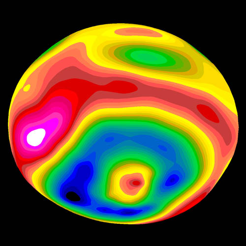
A color-encoded elevation map of Vesta clearly shows the giant 460-kilometer diameter impact basin and "bull's-eye" central peak. The map was constructed from 78 Wide Field Planetary Camera 2 pictures. Surface topography was estimated by noting irregularities along the limb and at the terminator (day/night boundary) where shadows are enhanced by the low Sun angle. Deutsch: Farbkodierte Höhenkarte von Vesta.
Polski: Mapa Westy ukazująca różnice w wysokościach na jej powierzchni |
| 日期 | Image published 1997 September 4 |
| 來源 | http://hubblesite.org/newscenter/newsdesk/archive/releases/1997/27/image/e |
| 作者 | Ben Zellner (Georgia Southern University) and NASA |
| 授權許可 (重用此檔案) |
Unless otherwise specifically stated, no claim to copyright is being asserted by STScI and it may be freely used as in the public domain in accordance with NASA's contract. [...] [1] |
| 本作品由NASA創作,屬於公有領域。根據NASA的版權政策:“NASA的創作除非另有聲明否則不受版權保護。”(參見:Template:PD-USGov/zh,NASA版權政策或JPL圖像使用政策) | ||
 |
警告:
|
檔案歷史
點選日期/時間以檢視該時間的檔案版本。
| 日期/時間 | 縮圖 | 尺寸 | 使用者 | 備註 | |
|---|---|---|---|---|---|
| 目前 | 2006年1月30日 (一) 07:57 | | 500 × 500(43 KB) | Arnomane | higher resolution |
| 2005年8月24日 (三) 17:56 |  | 200 × 200(6 KB) | Vesta~commonswiki | * Description: A color-encoded elevation map of Vesta clearly shows the giant 460-kilometer diameter impact basin and "bull's-eye" central peak. The map was constructed from 78 Wide Field Planetary Camera 2 pictures. Surface topography was estimated by no |
檔案用途
下列頁面有用到此檔案:
全域檔案使用狀況
以下其他 wiki 使用了這個檔案:
- als.wikipedia.org 的使用狀況
- ar.wikipedia.org 的使用狀況
- ca.wikipedia.org 的使用狀況
- cs.wikipedia.org 的使用狀況
- de.wikipedia.org 的使用狀況
- en.wikipedia.org 的使用狀況
- es.wikipedia.org 的使用狀況
- eu.wikipedia.org 的使用狀況
- fa.wikipedia.org 的使用狀況
- fi.wikipedia.org 的使用狀況
- fr.wikipedia.org 的使用狀況
- ko.wikipedia.org 的使用狀況
- lb.wikipedia.org 的使用狀況
- mk.wikipedia.org 的使用狀況
- oc.wikipedia.org 的使用狀況
- pt.wikipedia.org 的使用狀況
- ro.wikipedia.org 的使用狀況
- simple.wikipedia.org 的使用狀況
- sk.wikipedia.org 的使用狀況
- sv.wikipedia.org 的使用狀況
- uk.wikipedia.org 的使用狀況
- www.wikidata.org 的使用狀況