
File:1852 Middlesex Canal (Massachusetts) map.jpg

本预览的尺寸:411 × 599像素。 其他分辨率:165 × 240像素 | 329 × 480像素 | 527 × 768像素 | 703 × 1,024像素 | 2,310 × 3,365像素。
原始文件 (2,310 × 3,365像素,文件大小:9.03 MB,MIME类型:image/jpeg)
_map.jpg?uselang=zh)
_map.jpg?uselang=zh)
_map.jpg?action=history&uselang=zh)
_map.jpg)
摘要
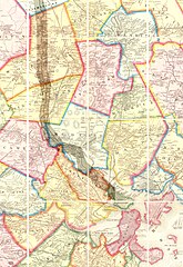
| 描述 | Map of the lower stretch of the Middlesex Canal, north of Boston, Massachusetts, 1852. This map was made about the time the canal was abandoned, some 50 years after its construction was completed. |
| 日期 | |
| 来源 | Map entitled "Boston and vicinity", by F. G. Sidney and R. P. Smith, published by J. B. Shields of Boston, 1852. This scan is from the David Rumsey Map Collection, and has been cropped to remove extraneous terrain and digitally enhanced to emphasize the canal's route. |
| 作者 | F. G. Sidney and R. P. Smith. |
| 授权 (二次使用本文件) |
The following text is taken from the David Rumsey web site: Images copyright © 2000 by Cartography Associates. Images may be reproduced or transmitted, but not for commercial use. For commercial use or commercial republication, contact carto@luna-img.com. This work is licensed under a Creative Commons License. |
许可协议
文件历史
点击某个日期/时间查看对应时刻的文件。
| 日期/时间 | 缩略图 | 大小 | 用户 | 备注 | |
|---|---|---|---|---|---|
| 当前 | 2007年1月14日 (日) 16:49 | | 2,310 × 3,365(9.03 MB) | Daderot | {{Information |Description=Map of the lower stretch of the Middlesex Canal, north of Boston, Massachusetts, 1852. This map was made about the time the canal was abandoned, some 50 years after its construction was completed. |Source=Map entitled "Boston an |
文件用途
以下页面使用本文件:
全域文件用途
以下其他wiki使用此文件:
- arz.wikipedia.org上的用途
- ceb.wikipedia.org上的用途
- de.wikipedia.org上的用途
- en.wikipedia.org上的用途
- Cambridge, Massachusetts
- Everett, Massachusetts
- Malden, Massachusetts
- Medford, Massachusetts
- Melrose, Massachusetts
- Woburn, Massachusetts
- Arlington, Massachusetts
- Reading, Massachusetts
- Stoneham, Massachusetts
- Wakefield, Massachusetts
- Winchester, Massachusetts
- Brighton, Boston
- Middlesex Canal
- History of Boston
- fr.wikipedia.org上的用途
- he.wikipedia.org上的用途
- it.wikipedia.org上的用途
- ja.wikipedia.org上的用途
- pt.wikipedia.org上的用途
- ro.wikipedia.org上的用途
- ru.wikipedia.org上的用途
- uk.wikipedia.org上的用途
- www.wikidata.org上的用途
_map.jpg)