
File:1866 U.S. Coast Survey Nautical Chart of Map of New York City and Harbor - Geographicus - NewYorkCity3-uscs-1866.jpg

本预览的尺寸:520 × 599像素。 其他分辨率:208 × 240像素 | 417 × 480像素 | 667 × 768像素 | 889 × 1,024像素 | 1,778 × 2,048像素 | 5,209 × 6,000像素。
原始文件 (5,209 × 6,000像素,文件大小:7.11 MB,MIME类型:image/jpeg)
摘要
| Coast Chart No. 20, New York Bay and Harbor, New York. | |||
|---|---|---|---|
| 艺术家 | |||
| 标题 |
Coast Chart No. 20, New York Bay and Harbor, New York. |
||
| 描述 |
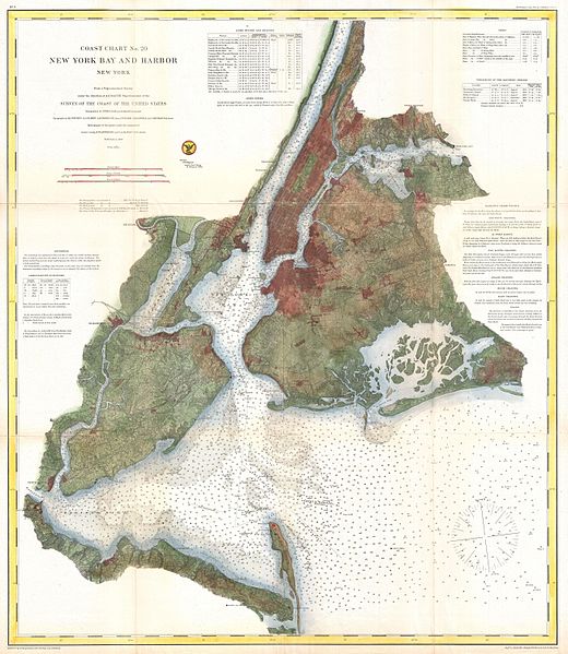
English: A rare 1866 coastal chart of New York City, it’s harbor, and environs. One of the first 19th century carts to depicts New York City as we know it today, including Manhattan, Queens, Brooklyn, the Bronx and Staten Island. Also includes Jersey City, Newark and Hoboken. This is possibly the most advanced chart in this series with far more detail than previous editions. In addition to inland details, this chart contains a wealth of practical information for the mariner from oceanic depths, to harbors and navigation tips on important channels. Map also includes tables of light houses and beacons, tides and magnetic declination as well as detailed sailing instructions. The triangulation for this chart was prepared by J. Ferguson and E. Blunt. The topography by H. L. Whiting, S. A. Gilbert, A. M Harrison, F. W. Door, C. Rockwell and J. M E. Chan. The hydrography was accomplished by R. Wainwright and T. A. Craven. The entire production was supervised by A. D. Bache, Superintendent of the Survey of the Coast of the United States and one of the most influential American cartographers of the 19th century. |
||
| 日期 | 1866年 (dated) | ||
| 尺寸 | 高度:31英寸(78.7厘米);寬度:27英寸(68.5厘米) | ||
| 登录号 |
Geographicus link: NewYorkCity3-uscs-1866 |
||
| 来源/摄影师 |
Report of the Superintendant of the United States Coast Survey, Washington, (1867 Supplement to the 1865 edition).
|
||
许可协议
|
公有领域作品必须在美国以及来源国没有版权问题,才能上传至维基共享资源。如果此作品不是美国作品,这个文件必须要有一个额外的版权标记显示此文件在来源国的版权状态。
注意:此标签不应用于录音作品。 |
文件历史
点击某个日期/时间查看对应时刻的文件。
| 日期/时间 | 缩略图 | 大小 | 用户 | 备注 | |
|---|---|---|---|---|---|
| 当前 | 2011年3月23日 (三) 16:33 | | 5,209 × 6,000(7.11 MB) | BotMultichillT | {{subst:User:Multichill/Geographicus |link=http://www.geographicus.com/P/AntiqueMap/NewYorkCity3-uscs-1866 |product_name=1866 U.S. Coast Survey Nautical Chart of Map of New York City and Harbor |map_title=Coast Chart No. 20, New York Bay and Harbor, New Y |
文件用途
以下页面使用本文件:
全域文件用途
以下其他wiki使用此文件:
- en.wikipedia.org上的用途