
File:2011 Census Scheduled Caste caste distribution map India by state and union territory.svg

此SVG文件的PNG预览的大小:531 × 599像素。 其他分辨率:213 × 240像素 | 425 × 480像素 | 681 × 768像素 | 907 × 1,024像素 | 1,815 × 2,048像素 | 1,650 × 1,862像素。
原始文件 (SVG文件,尺寸为1,650 × 1,862像素,文件大小:1.44 MB)
摘要
| 描述 |
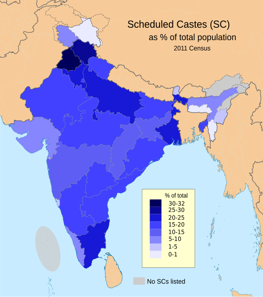
English: This demographic map shows Scheduled Castes (SC, Dalit) as a percent of each state and union territory's population per 2011 Census of India. Punjab had the highest percentage Dalit population in 2011 among all Indian states (31.9%), while Nagaland, Arunachal Pradesh, Andaman & Nicobar Islands and Lakshadweep had 0%.
Source: Census of India 2011, Primary Census Abstract - Scheduled castes and scheduled tribes, Office of the Registrar General & Census Commissioner, India (October 28 2013). The data can be viewed in a Powerpoint presentation on a Government of India Census website here. The disputed national borders SVG code in this map is a derivative work of File:India literacy rate map en.svg available on wikimedia commons. |
| 日期 | |
| 来源 | 自己的作品 |
| 作者 | M Tracy Hunter |
许可协议
我,本作品著作权人,特此采用以下许可协议发表本作品:
本文件采用知识共享署名-相同方式共享 3.0 未本地化版本许可协议授权。
- 您可以自由地:
- 共享 – 复制、发行并传播本作品
- 修改 – 改编作品
- 惟须遵守下列条件:
- 署名 – 您必须对作品进行署名,提供授权条款的链接,并说明是否对原始内容进行了更改。您可以用任何合理的方式来署名,但不得以任何方式表明许可人认可您或您的使用。
- 相同方式共享 – 如果您再混合、转换或者基于本作品进行创作,您必须以与原先许可协议相同或相兼容的许可协议分发您贡献的作品。
文件历史
点击某个日期/时间查看对应时刻的文件。
| 日期/时间 | 缩略图 | 大小 | 用户 | 备注 | |
|---|---|---|---|---|---|
| 当前 | 2023年3月8日 (三) 19:21 | | 1,650 × 1,862(1.44 MB) | Aishik Rehman | File uploaded using svgtranslate tool (https://svgtranslate.toolforge.org/). Added translation for bn. |
| 2020年6月1日 (一) 19:19 |  | 1,650 × 1,862(1.48 MB) | C1MM | Coloured island | |
| 2020年6月1日 (一) 19:16 |  | 1,650 × 1,862(1.48 MB) | C1MM | Removed fills | |
| 2020年3月22日 (日) 00:03 |  | 1,650 × 1,859(1.91 MB) | C1MM | Wording | |
| 2020年3月22日 (日) 00:02 |  | 1,650 × 1,859(1.91 MB) | C1MM | Added no SC locations | |
| 2020年3月21日 (六) 22:17 |  | 1,650 × 1,859(1.91 MB) | C1MM | Larger version of before file | |
| 2020年3月21日 (六) 22:14 |  | 1,650 × 1,859(1.9 MB) | C1MM | Removed unnecessary names of states and capitals, used different map for the states and added Ladakh and J&K as separate UTs | |
| 2015年8月23日 (日) 23:11 |  | 1,650 × 1,859(934 KB) | Utcursch | fix text flowing out of the image | |
| 2015年8月23日 (日) 22:54 |  | 1,578 × 1,738(862 KB) | Utcursch | use the term used in the source; see en:Talk:Dalit#Image_Remove | |
| 2014年7月16日 (三) 11:49 |  | 1,578 × 1,738(863 KB) | M Tracy Hunter | Caption |
文件用途
以下页面使用本文件:
全域文件用途
以下其他wiki使用此文件:
- as.wikipedia.org上的用途
- bh.wikipedia.org上的用途
- bn.wikipedia.org上的用途
- en.wikipedia.org上的用途
- eo.wikipedia.org上的用途
- es.wikipedia.org上的用途
- et.wikipedia.org上的用途
- he.wikipedia.org上的用途
- hi.wikipedia.org上的用途
- it.wikipedia.org上的用途
- lv.wikipedia.org上的用途
- ml.wikipedia.org上的用途
- mr.wikipedia.org上的用途
- ne.wikipedia.org上的用途
- nn.wikipedia.org上的用途
- pi.wikipedia.org上的用途
- ru.wikipedia.org上的用途
- sq.wikipedia.org上的用途
- ta.wikipedia.org上的用途
- th.wikipedia.org上的用途
- uk.wikipedia.org上的用途
- www.wikidata.org上的用途