
File:Argyle Cut.jpg
本预览的尺寸:800 × 567像素。 其他分辨率:320 × 227像素 | 640 × 454像素 | 1,024 × 726像素 | 1,121 × 795像素。
原始文件 (1,121 × 795像素,文件大小:52 KB,MIME类型:image/jpeg)
摘要
| 描述 |
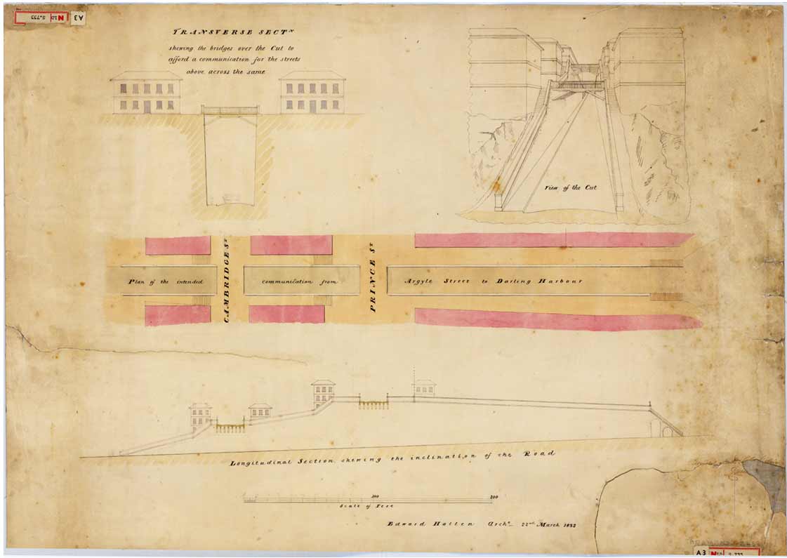
English: Transverse section showing the bridges over the [Argyle] Cut to afford a communication for the streets above, across the same, 22 March 1832
From the Surveyor General's Maps and plans. SRNSW: CGS 13859, [SZ 468]. This plan shows the bridges which were to be built over the Cut when it was completed. Convict labour was employed on the Argyle Cut which was made to give access from Sydney Cove to Miller's Point and Darling Harbour. Before the cut was excavated, pedestrians crossed the ridge by means of steps cut into the sandstone. The marks from the tools used in the operation remain as evidence of this feat of manual labour. The rock and rubble from the excavation was taken several hundred metres away to pack the mouth of the Tank Stream as a sea-wall at Circular Quay. http://www.records.nsw.gov.au/public/gallery/rocks/displays/displays-item-7.html |
| 日期 | |
| 来源 | http://www.records.nsw.gov.au/public/gallery/rocks/images/items/large/7.jpg |
| 作者 | From the Surveyor General's Maps and plans |
许可协议
此图片或其他作品来自澳大利亚,因为其著作权保护期限逾期,所以现在属于公有领域。根据澳大利亚版权协会(ACC)和ACC信息表格G023v19(版权期限)(2019年1月):1
使用此模板时,请提供有关图片首次出版的位置和作者的信息。 |
 | |||||||||||||||||||
文件历史
点击某个日期/时间查看对应时刻的文件。
| 日期/时间 | 缩略图 | 大小 | 用户 | 备注 | |
|---|---|---|---|---|---|
| 当前 | 2009年2月8日 (日) 23:15 | | 1,121 × 795(52 KB) | Macr | {{Information |Description={{en|1=Transverse section showing the bridges over the [Argyle] Cut to afford a communication for the streets above, across the same, 22 March 1832 From the Surveyor General's Maps and plans. SRNSW: CGS 13859, [SZ 468]. This p |
文件用途
以下页面使用本文件:
全域文件用途
以下其他wiki使用此文件:
- en.wikipedia.org上的用途
- ja.wikipedia.org上的用途
- ms.wikipedia.org上的用途