
File:Barrier route July 2011.png
本预览的尺寸:218 × 599像素。 其他分辨率:87 × 240像素 | 174 × 480像素 | 279 × 768像素 | 372 × 1,024像素 | 745 × 2,048像素 | 2,748 × 7,554像素。
原始文件 (2,748 × 7,554像素,文件大小:2.48 MB,MIME类型:image/png)
摘要
| 描写 |
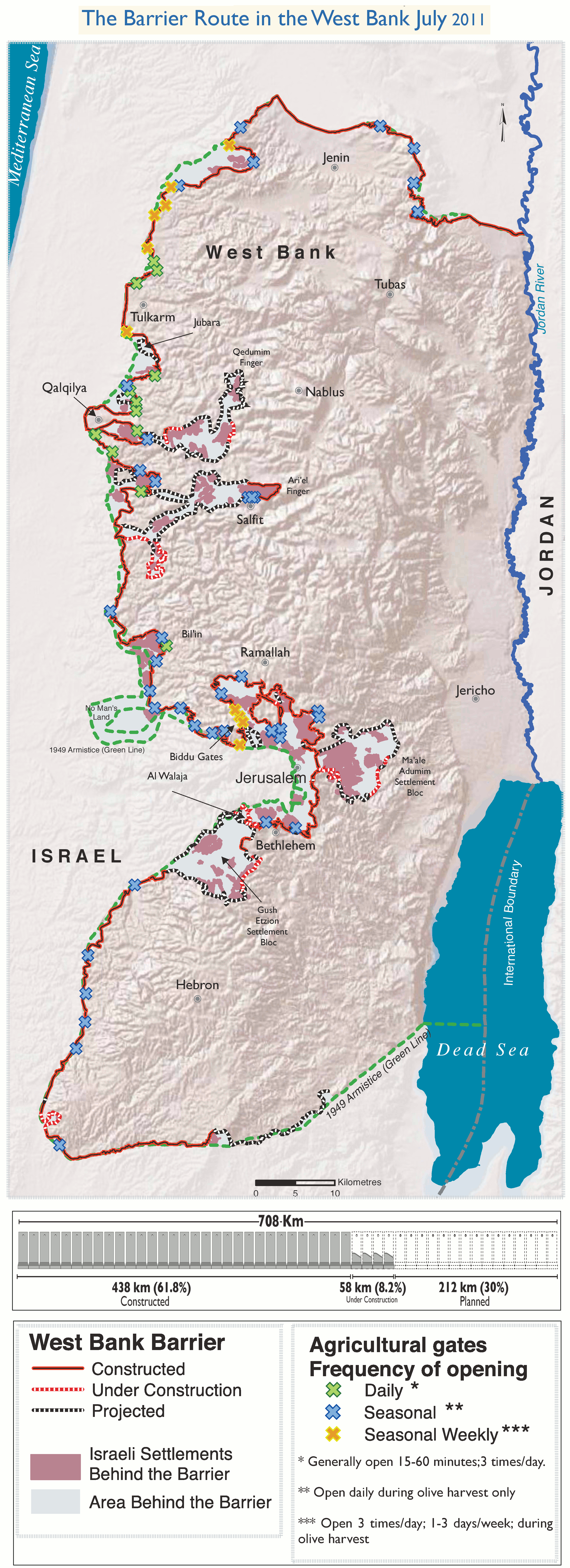
English: The Israeli West Bank barrier as of July 2011.
The planned route, the part already completed, the part under construction as well as the Wall Gates where Palestinian access is controled by the Israeli army. |
| 日期 | |
| 来源 | 自己的作品. Adaptation of http://www.ochaopt.org/documents/ocha_opt_west_bank_barrier_route_update_july_2011.pdf on OCHAoPt Map Centre. |
| 創作作者 | |
| 地理参考 | 如果不适当,请设置 warp_status = skip 为隐藏。 |
许可协议
我,本作品著作权人,特此采用以下许可协议发表本作品:
本文件采用知识共享署名 3.0 未本地化版本许可协议授权。
- 您可以自由地:
- 共享 – 复制、发行并传播本作品
- 修改 – 改编作品
- 惟须遵守下列条件:
- 署名 – 您必须对作品进行署名,提供授权条款的链接,并说明是否对原始内容进行了更改。您可以用任何合理的方式来署名,但不得以任何方式表明许可人认可您或您的使用。

文件历史
点击某个日期/时间查看对应时刻的文件。
| 日期/时间 | 缩略图 | 大小 | 用户 | 备注 | |
|---|---|---|---|---|---|
| 当前 | 2013年11月10日 (日) 10:29 | 2,748 × 7,554(2.48 MB) | Wickey-nl | User created page with UploadWizard |
文件用途
以下页面使用本文件:
全域文件用途
以下其他wiki使用此文件:
- bn.wikipedia.org上的用途
- el.wikipedia.org上的用途
- en.wikipedia.org上的用途
- eo.wikipedia.org上的用途
- fa.wikipedia.org上的用途
- fi.wikipedia.org上的用途
- fr.wikipedia.org上的用途
- ps.wikipedia.org上的用途
- pt.wikipedia.org上的用途
- sv.wikipedia.org上的用途
- tr.wikipedia.org上的用途