
File:Crozet Map.png
本预览的尺寸:800 × 473像素。 其他分辨率:320 × 189像素 | 640 × 378像素 | 1,024 × 605像素 | 1,280 × 757像素 | 2,280 × 1,348像素。
原始文件 (2,280 × 1,348像素,文件大小:246 KB,MIME类型:image/png)

|
此map图片可使用矢量图形重新创建为SVG文件。这具有很多好处;更多信息请参见共享资源:待清理媒体。如果存在此图片的SVG格式,请将其上传,然后将此模板替换为
{{vector version available|新图片名称}}。
建议您将SVG命名为“Crozet Map.svg”,这样在使用Vector version available(或Vva)模板时就不需要填写新图片名称参数。 |
摘要
| 描述 |
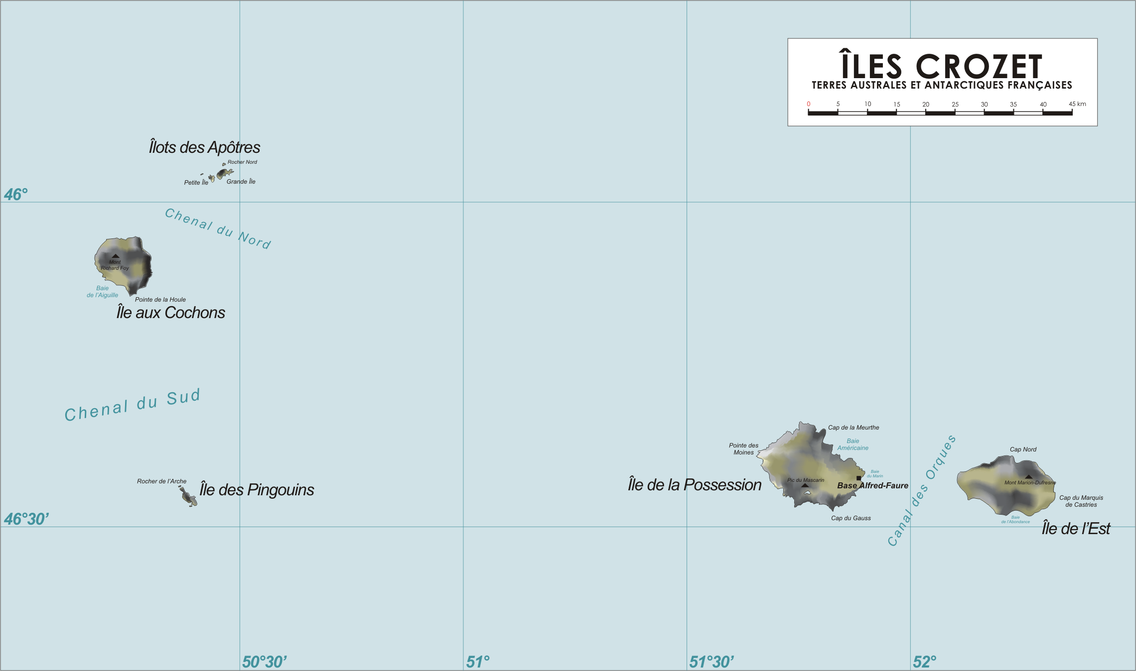
Map of the Crozet Islands, French Southern and Antarctic Territories
|
| 日期 | 2006年4月13日 (原始上传日期) |
| 来源 | 无法识别来源。根据版权声明推断为其自己的作品。 |
| 作者 | 无法识别作者。根据版权声明推断作者为Varp~commonswiki。 |
许可协议
| 我,本作品著作权人,释出本作品至公有领域。这适用于全世界。 在一些国家这可能不合法;如果是这样的话,那么: 我无条件地授予任何人以任何目的使用本作品的权利,除非这些条件是法律规定所必需的。 |
文件历史
点击某个日期/时间查看对应时刻的文件。
| 日期/时间 | 缩略图 | 大小 | 用户 | 备注 | |
|---|---|---|---|---|---|
| 当前 | 2006年4月13日 (四) 18:55 | | 2,280 × 1,348(246 KB) | Varp~commonswiki | |
| 2006年4月13日 (四) 11:45 |  | 2,280 × 1,348(242 KB) | Varp~commonswiki | *Map of the Crozet Islands, French Southern and Antarctic Territories *drawn by varp |
文件用途
以下页面使用本文件:
全域文件用途
以下其他wiki使用此文件:
- af.wikipedia.org上的用途
- ar.wikipedia.org上的用途
- ast.wikipedia.org上的用途
- az.wikipedia.org上的用途
- bg.wikipedia.org上的用途
- br.wikipedia.org上的用途
- ca.wikipedia.org上的用途
- cs.wikipedia.org上的用途
- da.wikipedia.org上的用途
- de.wikipedia.org上的用途
- de.wikivoyage.org上的用途
- el.wikipedia.org上的用途
- en.wikipedia.org上的用途
- en.wikivoyage.org上的用途
- eo.wikipedia.org上的用途
- es.wikipedia.org上的用途
- eu.wikipedia.org上的用途
- fi.wikipedia.org上的用途
- fr.wikipedia.org上的用途
- Archipel Crozet
- Marc Joseph Marion du Fresne
- Île aux Cochons
- Île des Pingouins
- Îlots des Apôtres
- Île de la Possession
- Île de l'Est
- Base Alfred-Faure
- Terres australes et antarctiques françaises
- Mont Marion-Dufresne
- Pic du Mascarin
- Mont Richard-Foy
- Mont des Manchots
- Mont Pierre
- Julien Crozet
- Baie Américaine
- Tamaris (voilier)
- Lac Perdu (archipel Crozet)
- Vallée de l'Au-delà
- Guillaume Lesquin
查看本文件的更多全域用途。