
File:Eritrean Railway - 2008-11-04-edit1.jpg

本预览的尺寸:800 × 600像素。 其他分辨率:320 × 240像素 | 640 × 480像素 | 1,024 × 768像素 | 1,280 × 960像素 | 2,400 × 1,800像素。
原始文件 (2,400 × 1,800像素,文件大小:1.86 MB,MIME类型:image/jpeg)
摘要
| 攝影師 |
Original photograph taken by User:Voice of Clam, edited by jjron - adjusted levels, reduced highlights, sharpened. |
| 描述 |
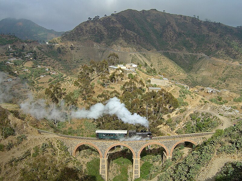
English: Eritrean Railway, showing mountainous terrain traversed between Arbaroba and Asmara.
Български: Еритрейската ЖП линия е посроена през италианското колониално време
Deutsch: Eisenbahn in Eritrea
Esperanto: Fervojoj en Eritreo
Español: Ferrocarril en Eritrea construido por los italianos
Français : Sur les chemins de fer érythréens, actuellement seulement exploités entre Massaoua et Asmara, une locomotive de la série 440 circule sur la section montagneuse entre Arbaroba et Asmara, au niveau de la « porte du Diable »
עברית: רכבת חוצה גשר באריתראה
Bahasa Indonesia: Jalur kereta api Eritrea, yang kini hanya menghubungkan Massawa dan Asmara
Italiano: Una locomotiva della Ferrovia Eritrea mentre attraversa gli altopiani
日本語: 山岳部を走るイタリア領時代に建設されたエリトリア鉄道
Ladino: Tréno en Eritrea de orijin italiano
Polski: Kolej Massaua - Asmara: Lokomotywa klasy 440 na odcinku Arbaroba - Asmara
پښتو: اریتره
Português: A Ferrovia da Eritreia foi construída durante o colonialismo italiano |
| 日期 | 摄于2008年11月4日 |
| 来源 | 本檔案衍生自: Eritrean Railway - 2008-11-04.jpg 通过 Voice of Clam |
| 授权 (二次使用本文件) |
See below |
| 其他版本 |
|
| Camera | Sony DSC-P12 |
| Notes |
|
| 联系 | I can be contacted: |
| See also |
|


| 相机位置 | | 在以下服务上查看本图像和附近其他图像: OpenStreetMap |
|---|
许可协议
| 本作品已被作者Voice of Clam释出到公有领域。这适用于全世界。 在一些国家这可能不合法;如果是这样的话,那么: Voice of Clam无条件地授予任何人以任何目的使用本作品的权利,除非这些条件是法律规定所必需的。 |
Assessments
|
derivative works
此文件衍生的作品: Eritrean Railway banner.jpg
文件历史
点击某个日期/时间查看对应时刻的文件。
| 日期/时间 | 缩略图 | 大小 | 用户 | 备注 | |
|---|---|---|---|---|---|
| 当前 | 2009年11月8日 (日) 18:55 | | 2,400 × 1,800(1.86 MB) | Voice of Clam | As this version is a Featured Image on enwiki, I do not think it is appropriate to replace it without discussion. I will upload the new version with a different name. |
| 2009年11月8日 (日) 05:42 |  | 2,400 × 1,800(1.87 MB) | Citypeek | white balance | |
| 2008年11月14日 (五) 12:38 |  | 2,400 × 1,800(1.86 MB) | Jjron | {{User:Tivedshambo/Information |Description={{w|Eritrean Railway}}, showing mountainous terrain traversed between Arbaroba and {{w|Asmara}}. <br>This is an edited version of Image:Eritrean Railway - Tivedshambo 2008-11-04.jpg by jjron |
文件用途
以下页面使用本文件:
全域文件用途
以下其他wiki使用此文件:
- bg.wikipedia.org上的用途
- bs.wikipedia.org上的用途
- cy.wikipedia.org上的用途
- de.wikipedia.org上的用途
- en.wikipedia.org上的用途
- Eritrean Railway
- 1911 in rail transport
- Portal:Africa/Featured picture
- Wikipedia:Featured pictures thumbs/14
- Wikipedia:Picture peer review/Archives/Oct-Dec 2008
- Wikipedia:Picture peer review/Eritrean Railway
- Wikipedia:Featured picture candidates/Eritrean Railway
- Wikipedia:Wikipedia Signpost/2009-01-03/Features and admins
- Wikipedia:Featured picture candidates/December-2008
- Portal:Africa/Featured picture/29
- Wikipedia:Picture of the day/September 2009
- Template:POTD/2009-09-15
- User talk:Sarah777/Archive 25
- Portal:Eritrea/Featured picture
- Portal:Eritrea/Featured article
- Portal:Eritrea/Featured picture/8
- Wikipedia:Featured pictures/Vehicles/Land
- Wikipedia:Wikipedia Signpost/2010-09-20/WikiProject report
- User talk:Voice of Clam/Archives/2008
- User talk:Voice of Clam/Archives/2009
- List of companies based in Eritrea
- Portal:Trains/Selected article/2014 archive
- Portal:Trains/Selected article/Week 34, 2014
- Wikipedia:Wikipedia Signpost/2009-01-03/SPV
- Wikipedia:Wikipedia Signpost/Single/2010-09-20
- User talk:Voice of Clam/Archives
- Portal:Trains/Did you know/December 2016
- User:Alb2017/sandbox
- Italian colonial railways
- Portal:Eritrea/Featured article/7
- User:Moonraker/P
- Wikipedia:Wikipedia Signpost/Single/2009-01-03
- eo.wikipedia.org上的用途
- es.wikipedia.org上的用途
- fa.wikipedia.org上的用途
- fr.wikipedia.org上的用途
- ha.wikipedia.org上的用途
- he.wikipedia.org上的用途
查看此文件的更多全域用途。