
File:Gaia’s first sky map ESA365175.png

原始文件 (3,840 × 2,400像素,文件大小:5.52 MB,MIME类型:image/png)
摘要
| 描述 |
English: An all-sky view of stars in our Galaxy – the Milky Way – and neighbouring galaxies, based on the first year of observations from ESA’s Gaia satellite, from July 2014 to September 2015.
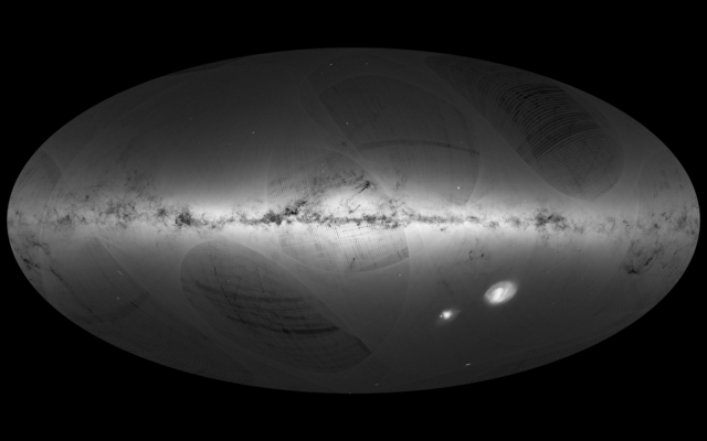
This map shows the density of stars observed by Gaia in each portion of the sky. Brighter regions indicate denser concentrations of stars, while darker regions correspond to patches of the sky where fewer stars are observed. The Milky Way is a spiral galaxy, with most of its stars residing in a disc about 100 000 light-years across and about 1000 light-years thick. This structure is visible in the sky as the Galactic Plane – the brightest portion of this image –which runs horizontally and is especially bright at the centre. Darker regions across the Galactic Plane correspond to dense clouds of interstellar gas and dust that absorb starlight along the line of sight. Many globular and open clusters – groupings of stars held together by their mutual gravity – are also sprinkled across the image. Globular clusters, large assemblies of hundreds of thousands to millions of old stars, are mainly found in the halo of the Milky Way, a roughly spherical structure with a radius of about 100 000 light-years, and so are visible across the image. Open clusters are smaller assemblies of hundreds to thousands of stars and are found mainly in the Galactic Plane. The two bright objects in the lower right of the image are the Large and Small Magellanic Clouds, two dwarf galaxies orbiting the Milky Way. Other nearby galaxies are also visible, most notably Andromeda (also known as M31), the largest galactic neighbour to the Milky Way, in the lower left of the image. Below Andromeda is its satellite, the Triangulum galaxy (M33). A number of artefacts are also visible on the image. These curved features and darker stripes are not of astronomical origin but rather reflect Gaia’s scanning procedure. As this map is based on observations performed during the mission’s first year, the survey is not yet uniform across the sky. These artefacts will gradually disappear as more data are gathered during the five-year mission. High resolution versions of the Gaia map, with transparent background, are available to download from:http://sci.esa.int/gaia/58209 Acknowledgement: A. Moitinho & M. Barros (CENTRA – University of Lisbon), on behalf of DPAC |
| 日期 | |
| 来源 | http://www.esa.int/spaceinimages/Images/2016/09/Gaia_s_first_sky_map |
| 作者 | European Space Agency |
| 授权 (二次使用本文件) |
ESA/Gaia/DPAC,CC BY-SA 3.0 IGO |
| Title | Gaia’s first sky map |
| Mission | Gaia |
| Activity | Space Science |
许可协议
- 您可以自由地:
- 共享 – 复制、发行并传播本作品
- 修改 – 改编作品
- 惟须遵守下列条件:
- 署名 – 您必须对作品进行署名,提供授权条款的链接,并说明是否对原始内容进行了更改。您可以用任何合理的方式来署名,但不得以任何方式表明许可人认可您或您的使用。
- 相同方式共享 – 如果您再混合、转换或者基于本作品进行创作,您必须以与原先许可协议相同或相兼容的许可协议分发您贡献的作品。
文件历史
点击某个日期/时间查看对应时刻的文件。
| 日期/时间 | 缩略图 | 大小 | 用户 | 备注 | |
|---|---|---|---|---|---|
| 当前 | 2017年9月24日 (日) 09:33 | | 3,840 × 2,400(5.52 MB) | Fæ | European Space Agency, Id 365175, http://www.esa.int/spaceinimages/Images/2016/09/Gaia_s_first_sky_map, User:Fæ/Project_list/ESA |
文件用途
以下页面使用本文件:
全域文件用途
以下其他wiki使用此文件:
- de.wikipedia.org上的用途
- en.wikipedia.org上的用途
- gl.wikipedia.org上的用途
- www.wikidata.org上的用途