
File:Grand cayman.jpg

本预览的尺寸:603 × 599像素。 其他分辨率:242 × 240像素 | 483 × 480像素 | 773 × 768像素 | 1,031 × 1,024像素 | 2,061 × 2,048像素 | 5,059 × 5,026像素。
原始文件 (5,059 × 5,026像素,文件大小:2.34 MB,MIME类型:image/jpeg)
| 描述 |
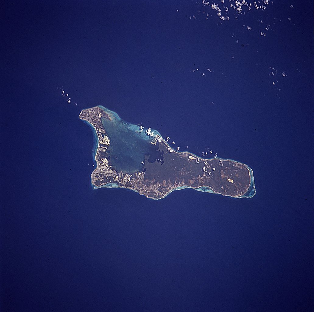
English: The island of Grand Cayman, a British dependency that covers 76 square miles (197 square kilometers) in the northwest Caribbean Sea, is visible in this near-vertical photograph. Geologically similar to The Bahamas, Grand Cayman is a low-lying, limestone island located on top of a submarine ridge. The city of George Town, the capital and chief port of the Cayman Islands, can be seen at the southwest end of the island. Grand Cayman’s 7-mile beach can be seen on the western side of the island. The image was taken from an altitude of 115 nautical miles (213km); North is up in this image. |
|||||
| 日期 | April 15, 1994 18:38 (UTC?) | |||||
| 来源 | NASA, Astronaut Photography of Earth: Image STS059-227-42. | |||||
| 作者 | NASA | |||||
| 授权 (二次使用本文件) |
|

本图像或视频收录于美国国家航空航天局 (NASA)某个部门,其照片编号是: STS059-227-42 此标签不表示文件的著作权状态。任何文件在附有此标签的同時还需要一个有效的著作权标签。请参阅许可协议说明页面以了解更多信息。 其他语言:
|
文件历史
点击某个日期/时间查看对应时刻的文件。
| 日期/时间 | 缩略图 | 大小 | 用户 | 备注 | |
|---|---|---|---|---|---|
| 当前 | 2007年11月20日 (二) 11:09 | | 5,059 × 5,026(2.34 MB) | Lupo | Much larger version from NASA [http://eol.jsc.nasa.gov/scripts/sseop/photo.pl?mission=STS059&roll=227&frame=42 Image STS059-227-42 (rotated)] |
| 2006年10月3日 (二) 16:21 |  | 639 × 639(77 KB) | AxeEffect |
文件用途
以下页面使用本文件:
全域文件用途
以下其他wiki使用此文件:
- ar.wikipedia.org上的用途
- be.wikipedia.org上的用途
- ca.wikipedia.org上的用途
- ceb.wikipedia.org上的用途
- da.wikipedia.org上的用途
- de.wikipedia.org上的用途
- el.wikipedia.org上的用途
- en.wikipedia.org上的用途
- eo.wikipedia.org上的用途
- es.wikipedia.org上的用途
- fa.wikipedia.org上的用途
- fi.wikipedia.org上的用途
- fr.wikipedia.org上的用途
- he.wikipedia.org上的用途
- hr.wikipedia.org上的用途
- hu.wikipedia.org上的用途
- id.wikipedia.org上的用途
- it.wikipedia.org上的用途
- it.wikivoyage.org上的用途
- lt.wikipedia.org上的用途
- nl.wikipedia.org上的用途
- no.wikipedia.org上的用途
- pl.wikipedia.org上的用途
- ru.wikipedia.org上的用途
- sh.wikipedia.org上的用途
- simple.wikipedia.org上的用途
- sv.wikipedia.org上的用途
- tr.wikipedia.org上的用途
- uk.wikipedia.org上的用途
- www.wikidata.org上的用途