
File:Map Clervaux.png
此为最大尺寸。
Map_Clervaux.png (203 × 270像素,文件大小:7 KB,MIME类型:image/png)
摘要
| 描述 |
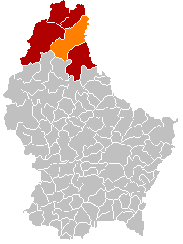
English: Clervaux municipality location after merging of municipalities (valid from 1 January 2012) |
| 日期 | |
| 来源 |
English: Own edit of File:Map Clervaux.PNG |
| 作者 | Les Meloures |
许可协议
| 我,本作品著作权人,释出本作品至公有领域。这适用于全世界。 在一些国家这可能不合法;如果是这样的话,那么: 我无条件地授予任何人以任何目的使用本作品的权利,除非这些条件是法律规定所必需的。 |
文件历史
点击某个日期/时间查看对应时刻的文件。
| 日期/时间 | 缩略图 | 大小 | 用户 | 备注 | |
|---|---|---|---|---|---|
| 当前 | 2018年1月8日 (一) 17:48 | | 203 × 270(7 KB) | NordNordWest | corr |
| 2018年1月8日 (一) 17:27 |  | 203 × 270(5 KB) | NordNordWest | upd | |
| 2015年11月10日 (二) 20:57 |  | 203 × 270(5 KB) | NordNordWest | no more districts in Luxembourg | |
| 2011年10月27日 (四) 18:52 |  | 203 × 270(3 KB) | Les Meloures | New map after changes in municipalities in Luxembourg | |
| 2011年10月27日 (四) 18:40 |  | 203 × 270(3 KB) | Les Meloures | {{Information |Description ={{en|1=Location Clervaux after changes of municipalities}} |Source ={{own}} |Author =Les Meloures |Date =2011-11-24 |Permission = |other_versions = }} |
文件用途
以下页面使用本文件:
全域文件用途
以下其他wiki使用此文件:
- als.wikipedia.org上的用途
- ca.wikipedia.org上的用途
- ceb.wikipedia.org上的用途
- de.wikipedia.org上的用途
- frr.wikipedia.org上的用途
- fr.wikipedia.org上的用途
- it.wikipedia.org上的用途
- lb.wikipedia.org上的用途
- li.wikipedia.org上的用途
- nl.wikipedia.org上的用途
- no.wikipedia.org上的用途
- simple.wikipedia.org上的用途
- sk.wikipedia.org上的用途
- sv.wikipedia.org上的用途