
File:Map of Bengal.svg

此SVG文件的PNG预览的大小:656 × 599像素。 其他分辨率:263 × 240像素 | 526 × 480像素 | 841 × 768像素 | 1,121 × 1,024像素 | 2,242 × 2,048像素 | 1,835 × 1,676像素。
原始文件 (SVG文件,尺寸为1,835 × 1,676像素,文件大小:1.32 MB)
摘要
| 描述 |
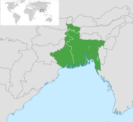
English: Map of Bengal. The region is today divided between East Bengal (Bangladesh) and West Bengal. Also showing the state of Tripura and the three districts of Cachar, Hailakandi and Karimganj; part of Barak Valley in Assam, India. Svenska: Karta av Bengal, delad mellan östra och västra. Staten Tripura och distrikten Hailakandi och Karimganj i södra Assam visas också. বাংলা: বাংলার মানচিত্র, পূর্ব ও পশ্চিমের মধ্যে বিভক্ত করা। মানচিত্রে চিহ্নিত রয়েছে বাংলাদেশের পূর্বে অবস্থিত বাংলাভাষী ভারতীয় রাজ্য ত্রিপুরা সহ আসাম রাজ্যের বরাক উপত্যকার তিনটি জেলা কাছাড়, হাইলাকান্দি এবং করিমগঞ্জ। |
| 日期 | |
| 来源 |
|
| 作者 | Goran tek-en |
| SVG开发 |

.svg)

许可协议
本文件采用知识共享署名-相同方式共享 4.0 国际许可协议授权。
署名: Goran tek-en
- 您可以自由地:
- 共享 – 复制、发行并传播本作品
- 修改 – 改编作品
- 惟须遵守下列条件:
- 署名 – 您必须对作品进行署名,提供授权条款的链接,并说明是否对原始内容进行了更改。您可以用任何合理的方式来署名,但不得以任何方式表明许可人认可您或您的使用。
- 相同方式共享 – 如果您再混合、转换或者基于本作品进行创作,您必须以与原先许可协议相同或相兼容的许可协议分发您贡献的作品。
文件历史
点击某个日期/时间查看对应时刻的文件。
| 日期/时间 | 缩略图 | 大小 | 用户 | 备注 | |
|---|---|---|---|---|---|
| 当前 | 2022年11月2日 (三) 10:03 | | 1,835 × 1,676(1.32 MB) | MS Sakib | Reverted to version as of 18:02, 10 March 2022 (UTC) (tripura and barak area are included in bengal region!) |
| 2022年10月4日 (二) 05:28 |  | 1,835 × 1,676(1.31 MB) | Msasag | Reverted to version as of 16:42, 4 October 2016 (UTC) | |
| 2022年3月10日 (四) 18:02 |  | 1,835 × 1,676(1.32 MB) | MS Sakib | Barak Valley area fixed | |
| 2017年11月12日 (日) 11:25 |  | 1,835 × 1,676(1.32 MB) | Mouryan | =={{int:filedesc}}== {{Information |description={{en|1=Map of Bengal, divided between east and west.}}{{sv|1=Karta av Bengal, delad mellan östra och västra.}}{{bn|1=বাংলার মানচিত্র, পূর্ব ও পশ্চিম... | |
| 2016年10月4日 (二) 16:42 |  | 1,835 × 1,676(1.31 MB) | BurritoBazooka | fix minimap bg turning up transparent in thumbnail? | |
| 2016年10月4日 (二) 16:40 |  | 1,835 × 1,676(1.31 MB) | BurritoBazooka | paste File:BlankMap-World gray.svg in again for minimap, this time with Alaska and Lesotho. | |
| 2013年12月1日 (日) 17:13 |  | 1,835 × 1,676(1.19 MB) | Goran tek-en | Enlarged map ~~~~ | |
| 2013年11月30日 (六) 17:53 |  | 1,836 × 1,679(1.2 MB) | Goran tek-en | User created page with UploadWizard |
文件用途
以下6个页面使用本文件:
全域文件用途
以下其他wiki使用此文件:
- af.wikipedia.org上的用途
- ang.wikipedia.org上的用途
- ar.wikipedia.org上的用途
- ast.wikipedia.org上的用途
- as.wikipedia.org上的用途
- azb.wikipedia.org上的用途
- az.wikipedia.org上的用途
- az.wikiquote.org上的用途
- be.wikipedia.org上的用途
- bg.wikipedia.org上的用途
- bn.wikipedia.org上的用途
- টেমপ্লেট:ব্যবহারকারী/বাঙালি
- বঙ্গ
- ব্যবহারকারী:Snthakur
- ব্যবহারকারী:Wiki naogaon
- বঙ্গভঙ্গ (১৯৪৭)
- ব্যবহারকারী:Ali Haidar Khan
- ব্যবহারকারী:Tanveer.nonstop
- ব্যবহারকারী:Faysal
- ব্যবহারকারী:Jonoikobangali
- ব্যবহারকারী:Jayantanth/Userboxes
- ব্যবহারকারী:Yahia.barie
- ব্যবহারকারী:Tarunno
- ব্যবহারকারী:Ikfaisal
- প্রবেশদ্বার:বাংলাদেশ
- ব্যবহারকারী:Pasaban
- ব্যবহারকারী:Wildscop
- ব্যবহারকারী:Rezowan
- ব্যবহারকারী:ছেঁড়াবাকল
- ব্যবহারকারী:DesiNinja
- ব্যবহারকারী:Hemayet
- ব্যবহারকারী:Hemayetfaridpur
- ব্যবহারকারী:004satcho
- ব্যবহারকারী:Babaidmun
- ব্যবহারকারী:Bodhisattwa
- ব্যবহারকারী:Akramul Hoque Samim
- ব্যবহারকারী:শাহনেওয়াজ শুভ
- ব্যবহারকারী:Muhammad Tasbir Iftekhar
- ব্যবহারকারী:Mohd. Toukir Hamid
- ব্যবহারকারী:ইউক্লিড রনি
- ব্যবহারকারী:Sukanta Sarkar
- ব্যবহারকারী:Ashiq Shawon
- ব্যবহারকারী:Asaduzzamana
- ব্যবহারকারী:Akash Islam
- ব্যবহারকারী:Sabarni sarker
- ব্যবহারকারী:হাসান মাহমুদ
- ব্যবহারকারী:Md.Faysal Alam Riyad
查看本文件的更多全域用途。