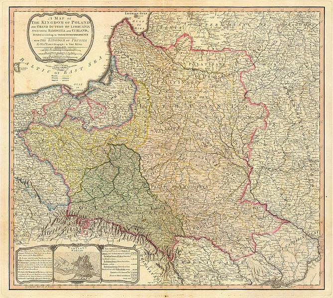
File:Map of the partition of the Kingdom of Poland and the Grand Duchy of Lithuania from 1799.jpg
页面内容不支持其他语言。
這個文件來自維基共享資源
维基百科,自由的百科全书

原始文件(6,330 × 5,677像素,文件大小:6.83 MB,MIME类型:image/jpeg


摘要

描述 Title: "A map of the Kingdom of Poland and the Grand Duchy of Lithuania including Samogitia and Curland divided according to their dismemberments with the Kingdom of Prussia". A map from 1799 showing how the Polish-Lithuanian Commonwealth was partitioned in 1765-1795 between Prussia, Austria, and Russia. This is an extremely detailed map which lists all the cities and small towns and labels the regions according to their English names. The boundaries former Polish-Lithuanian Commonwealth colored light red. The areas taken by Prussia are colored yellow, those taken by Austria colored green, and those taken by Russia are colored beige. Prussia itself is bordered in blue. Eastern Pomerania and Warmia are shown as part of Prussia but bordered in red as well.
日期
来源 http://www.belarusguide.com/images/maps/Kokosha/POlonia&Lituania-1799.jpg
作者
威廉·法登  (1749–1836)  wikidata:Q8008902
 
其他姓名
Faden & Jefferys
描述 英国製圖師和出版者
出生/逝世日期 约1750年
date QS:P,+1750-00-00T00:00:00Z/9,P1480,Q5727902
1836年3月21日 在維基數據編輯
出生/逝世地点 倫敦 謝珀頓
工作地点
From 1771: "Geographer to the King and to the Prince of Wales"
權威控制
creator QS:P170,Q8008902

许可协议

Public domain

本作品在其来源国以及其他著作权期限是作者逝世后100年或以下的国家和地区属于公有领域


你必须增加美国公有领域标签显示为何这个作品在美国属于公有领域。

说明

添加一行文字以描述该文件所表现的内容

此文件中描述的项目

描繪內容

2 4 1799格里历

文件历史

点击某个日期/时间查看对应时刻的文件。

日期/时间缩⁠略⁠图大小用户备注
当前2007年9月23日 (日) 05:042007年9月23日 (日) 05:04版本的缩略图6,330 × 5,677(6.83 MB)Archaeogenetics{{Information |Description=Title: "A map of the Kingdom of Poland and the Grand Duchy of Lithuania including Samogitia and Curland divided according to their dismemberments with the Kingdom of Prussia". A map from 1799 showing how the Polish-Lithuanian Co

以下页面使用本文件:

全域文件用途

以下其他wiki使用此文件:

元数据