
File:Mweru-Luapula.jpg
本预览的尺寸:250 × 599像素。 其他分辨率:100 × 240像素 | 396 × 949像素。
原始文件 (396 × 949像素,文件大小:79 KB,MIME类型:image/jpeg)
摘要
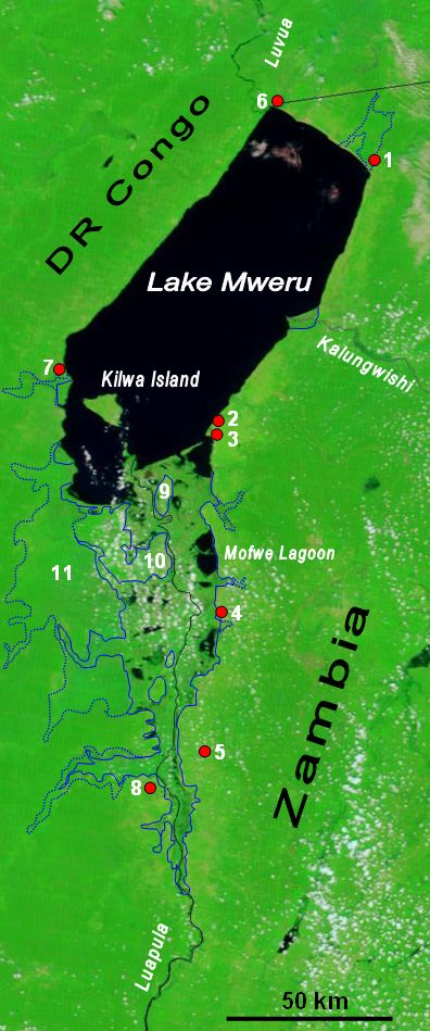
| 描述 | The lower Luapula River, its delta where it enters Lake Mweru, and Mweru's outlet, the Luvua River going on north to the Lualaba and Congo rivers. Water shows up as black in this false-colour NASA satellite image. The extent of the Luapula Swamps is shown by the solid blue line, and the extent of the floodplain is shown as a dotted line. The towns are, in Zambia: 1 Chiengi, 2 Kashikishi, 3 Nchelenge, 4 Mwansabombwe, 5 Mwense; in DR Congo: 6 Pweto, 7 Kilwa, 8 Kasenga. Other features: 9 Chisenga Island, 10 the largest swamp island (in DR Congo), 11 the main floodplain. |
| 日期 | |
| 来源 | Image NASA Visible Earth website, overlay in Word |
| 作者 | NASA credit Jacques Descloitres, MODIS Rapid Response Team, NASA/GSFC; overlay by User:Rexparry_sydney |
| 授权 (二次使用本文件) |
NASA public domain and my permission for overlay to also be Public Domain. |
许可协议
| 本文件完全由NASA创作,在美国属于公有领域。根据NASA的版权方针,NASA的材料除非另有声明否则不受版权保护。(参见Template:PD-USGov/zh、NASA版权方针页面或JPL图片使用方针。) | ||
 |
警告:
|
文件历史
点击某个日期/时间查看对应时刻的文件。
| 日期/时间 | 缩略图 | 大小 | 用户 | 备注 | |
|---|---|---|---|---|---|
| 当前 | 2007年3月28日 (三) 03:51 | | 396 × 949(79 KB) | Rexparry sydney~commonswiki | {{Information |Description=The lower Luapula River, its delta where is enters Lake Mweru, and Mweru's outlet, the Luvua River going on north to the Lualaba and Congo rivers. Water shows up as black in this false-colour NASA satellite image. The extent of |
文件用途
全域文件用途
以下其他wiki使用此文件:
- af.wikipedia.org上的用途
- ar.wikipedia.org上的用途
- bg.wikipedia.org上的用途
- ca.wikipedia.org上的用途
- ceb.wikipedia.org上的用途
- da.wikipedia.org上的用途
- de.wikipedia.org上的用途
- en.wikipedia.org上的用途
- es.wikipedia.org上的用途
- fa.wikipedia.org上的用途
- ff.wikipedia.org上的用途
- ha.wikipedia.org上的用途
- hu.wikipedia.org上的用途
- incubator.wikimedia.org上的用途
- it.wikipedia.org上的用途
- ka.wikipedia.org上的用途
- nl.wikipedia.org上的用途
- no.wikipedia.org上的用途
- pl.wikipedia.org上的用途
- ru.wikipedia.org上的用途
- rw.wikipedia.org上的用途
- simple.wikipedia.org上的用途
- sr.wikipedia.org上的用途
- sv.wikipedia.org上的用途
- sw.wikipedia.org上的用途
- www.wikidata.org上的用途