
File:Netherlands during French administration 1810-1814.png

本预览的尺寸:408 × 599像素。 其他分辨率:163 × 240像素 | 520 × 764像素。
原始文件 (520 × 764像素,文件大小:889 KB,MIME类型:image/png)
摘要
| 描述 |
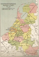
English: Map of Belgium and the Netherlands during the French occupation. Français : Carte de la Belgique et des Pays-Bas pendant l'occupation française. |
||||||||||||||||||||
| 日期 | 在1910年之前 | ||||||||||||||||||||
| 来源 | Scan from Atlas de géographie physique, politique et historique à l'usage de l'enseignement primaire et de l'enseignement moyen, Dessain, Liège, 35e éd., s.d., p. 40. | ||||||||||||||||||||
| 作者 |
|
||||||||||||||||||||

许可协议
|
本作品在其来源国以及其他著作权期限是作者逝世后100年或以下的国家和地区属于公有领域。 | |
| 本文件已被确认为免除已知的著作权法限制(包括所有相关权利)。 | |
文件历史
点击某个日期/时间查看对应时刻的文件。
| 日期/时间 | 缩略图 | 大小 | 用户 | 备注 | |
|---|---|---|---|---|---|
| 当前 | 2005年10月31日 (一) 11:16 | | 520 × 764(889 KB) | BrightRaven | Map of Belgium and the Netherlands during the French occupation. Author : MG Alexis |
文件用途
以下页面使用本文件:
全域文件用途
以下其他wiki使用此文件:
- ar.wikipedia.org上的用途
- ast.wikipedia.org上的用途
- br.wikipedia.org上的用途
- ca.wikipedia.org上的用途
- cs.wikipedia.org上的用途
- en.wikipedia.org上的用途
- eo.wikipedia.org上的用途
- es.wikipedia.org上的用途
- fr.wikipedia.org上的用途
- fy.wikipedia.org上的用途
- gl.wikipedia.org上的用途
- id.wikipedia.org上的用途
- it.wikipedia.org上的用途
- la.wikipedia.org上的用途
- li.wikipedia.org上的用途
- mt.wikipedia.org上的用途
- nl.wikipedia.org上的用途
- vls.wikipedia.org上的用途