
File:Nevado del Ruiz hazard map, from Wright and Pierson.png
此为最大尺寸。
Nevado_del_Ruiz_hazard_map,_from_Wright_and_Pierson.png (675 × 450像素,文件大小:324 KB,MIME类型:image/png)

|
本图像(或者本分类中的所有图像)用一个特殊的脚本或语言在内部使用了标签或附属的说明文字,这可以转换为语言中立图表。这样它可以用于所有的维基媒体计划,更重要的是,可以用于所有语言版本的维基媒体计划。
|

|
此map图片可使用矢量图形重新创建为SVG文件。这具有很多好处;更多信息请参见共享资源:待清理媒体。如果存在此图片的SVG格式,请将其上传,然后将此模板替换为
{{vector version available|新图片名称}}。
建议您将SVG命名为“Nevado del Ruiz hazard map, from Wright and Pierson.svg”,这样在使用Vector version available(或Vva)模板时就不需要填写新图片名称参数。 |
摘要
| 描述 |
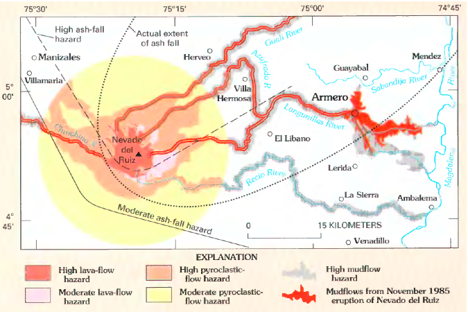
English: Volcanic hazard map for Nevado del Ruiz. Lahars from 1985 eruption (which killed around 23,000 people) shown in red.
Original caption: "Map showing hazards expected from an eruption of Nevado del Ruiz, Colombia. Such a map was prepared by INGEOMINAS (Colombian Institute of Geology and Mines) and circulated 1 month prior to the November 13, 1985, eruption of Nevado del Ruiz. Map shows danger from mudflows in the valley occupied by the town of Armero, Colombia, as well as areas affected by the hazards that resulted from this eruption. Circle denotes 20-kilometer limit." |
| 日期 | |
| 来源 | Page 21 in Wright, Thomas L. and Pierson, Thomas C. (1992). Living with volcanoes (DJVU format), USGS Circular 1073. Bibliographic information and link to DJVU reader are online here. |
| 作者 | Wright, Thomas L. and Pierson, Thomas C. |
| 其他版本 |
|

许可协议
|
|
文件历史
点击某个日期/时间查看对应时刻的文件。
| 日期/时间 | 缩略图 | 大小 | 用户 | 备注 | |
|---|---|---|---|---|---|
| 当前 | 2011年2月19日 (六) 15:38 | | 675 × 450(324 KB) | Lluis tgn | Reverted to version as of 23:46, 31 March 2009. It was in catalan |
| 2011年2月19日 (六) 14:30 |  | 675 × 450(284 KB) | Jadelllave | ({{Information |Description={{ca|1=Mapa dels perills volcànics de Nevado del Ruiz. Els lahars de l'erupció de 1985 (que va matar al voltant de 23.000 persones) es mostren en vermell.}}}} | |
| 2011年2月19日 (六) 14:26 |  | 675 × 450(284 KB) | Jadelllave | Translation of the names to catalan. | |
| 2009年3月31日 (二) 23:46 |  | 675 × 450(324 KB) | Avenue | {{Information |Description={{en|1=Volcanic hazard map for Nevado del Ruiz. Lahars from 1985 eruption (which killed around 23,000 people) shown in red. Original caption: "Map showing hazards expected from an eruption of Nevado del Ru |
文件用途
以下页面使用本文件:
全域文件用途
以下其他wiki使用此文件:
- ast.wikipedia.org上的用途
- en.wikipedia.org上的用途
- es.wikipedia.org上的用途
- fr.wikipedia.org上的用途
- ga.wikipedia.org上的用途
- he.wikipedia.org上的用途
- id.wikipedia.org上的用途
- it.wikipedia.org上的用途
- it.wikibooks.org上的用途
- ja.wikipedia.org上的用途
- mk.wikipedia.org上的用途
- nl.wikipedia.org上的用途
- pt.wikipedia.org上的用途
- ru.wikipedia.org上的用途
- sl.wikipedia.org上的用途
- uk.wikipedia.org上的用途