
File:Ottoman Provinces Of Present day Libya.png
此为最大尺寸。
Ottoman_Provinces_Of_Present_day_Libya.png (282 × 314像素,文件大小:22 KB,MIME类型:image/png)

|
此locator map图片可使用矢量图形重新创建为SVG文件。这具有很多好处;更多信息请参见共享资源:待清理媒体。如果存在此图片的SVG格式,请将其上传,然后将此模板替换为
{{vector version available|新图片名称}}。
建议您将SVG命名为“Ottoman Provinces Of Present day Libya.svg”,这样在使用Vector version available(或Vva)模板时就不需要填写新图片名称参数。 |
摘要
| 描述 |
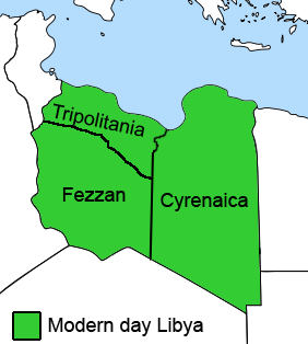
English: The Ottoman Turks conquered the country in the mid-16th century, and the three States or "Wilayat" of Tripolitania, Cyrenaica and Fezzan (which make up Libya) remained part of their empire with the exception of the virtual autonomy of the Karamanlis. The Karamanlis ruled from 1711 until 1835 mainly in Tripolitania, but had influence in Cyrenaica and Fezzan as well by the mid 18th century. |
||
| 日期 | |||
| 来源 | self-made but based on this image on this image and this image | ||
| 作者 | Esemono; improved by Kirk (talk) | ||
| 授权 (二次使用本文件) |
|
||
| 其他版本 |
此文件衍生的作品:
   |
文件历史
点击某个日期/时间查看对应时刻的文件。
| 日期/时间 | 缩略图 | 大小 | 用户 | 备注 | |
|---|---|---|---|---|---|
| 当前 | 2011年8月24日 (三) 12:53 | | 282 × 314(22 KB) | Kirk979 | See discussion |
| 2011年4月11日 (一) 20:46 |  | 300 × 350(35 KB) | ANGELUS | border | |
| 2011年4月11日 (一) 20:35 |  | 300 × 350(39 KB) | ANGELUS | improved | |
| 2009年10月12日 (一) 17:35 |  | 282 × 314(22 KB) | Kirk979 | corrections | |
| 2009年3月1日 (日) 11:00 |  | 282 × 314(29 KB) | Kirk979 | corrections | |
| 2008年4月17日 (四) 13:43 |  | 282 × 314(25 KB) | Esemono | Category:Maps of Libya Category:Map images that should use vector graphics |
文件用途
没有页面链接到本图像。
全域文件用途
以下其他wiki使用此文件:
- ar.wikipedia.org上的用途
- azb.wikipedia.org上的用途
- az.wikipedia.org上的用途
- be.wikipedia.org上的用途
- bg.wikipedia.org上的用途
- bs.wikipedia.org上的用途
- ca.wikipedia.org上的用途
- cs.wikipedia.org上的用途
- da.wikipedia.org上的用途
- el.wikipedia.org上的用途
- en.wikipedia.org上的用途
- Cyrenaica
- Districts of Libya
- Fezzan
- Tripolitania
- Governorates of Libya
- Subdivisions of Libya
- Provinces of Libya
- Postage stamps and postal history of Tripolitania
- Kingdom of Libya
- Postage stamps and postal history of Cyrenaica
- Postage stamps and postal history of Libya
- Postage stamps and postal history of Fezzan and Ghadames
- Template:Regions of Libya
- Category:Regions of Libya
- Revenue stamps of Libya
- Tripolitania (province of Libya)
- Cyrenaica province
- Fezzan province
查看本文件的更多全域用途。