
File:Peace-Athabasca Delta.JPG

本预览的尺寸:538 × 600像素。 其他分辨率:215 × 240像素 | 430 × 480像素 | 825 × 920像素。
原始文件 (825 × 920像素,文件大小:678 KB,MIME类型:image/jpeg)
摘要
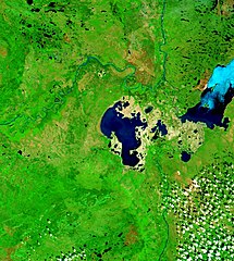
| 描述 | Peace-Athabasca Delta with Lake Claire and mouths of Peace River and Athabasca River. |
| 日期 | Visualization Date: 2002-09-21 |
| 来源 | Visible Earth, NASA |
| 作者 | Jacques Descloitres, MODIS Land Rapid Response Team, NASA/GSFC |
| 授权 (二次使用本文件) |
PD |
Cropped from the original 4800 x 3600 JPEG (4.4MB) image.
许可协议
| 本文件完全由NASA创作,在美国属于公有领域。根据NASA的版权方针,NASA的材料除非另有声明否则不受版权保护。(参见Template:PD-USGov/zh、NASA版权方针页面或JPL图片使用方针。) | ||
 |
警告:
|
文件历史
点击某个日期/时间查看对应时刻的文件。
| 日期/时间 | 缩略图 | 大小 | 用户 | 备注 | |
|---|---|---|---|---|---|
| 当前 | 2006年9月21日 (四) 14:28 | | 825 × 920(678 KB) | Qyd | {{Information |Description= Peace-Athabasca Delta with Lake Claire and mouths of Pecae River and Athabasca River. |Source= [http://visibleearth.nasa.gov/view_rec.php?id=6233 Visible Earth, NASA] |Date= Visualization Date: 2002-09-21 |Author= Jacques Des |
文件用途
以下页面使用本文件:
全域文件用途
以下其他wiki使用此文件:
- bg.wikipedia.org上的用途
- ca.wikipedia.org上的用途
- ceb.wikipedia.org上的用途
- cv.wikipedia.org上的用途
- de.wikipedia.org上的用途
- en.wikipedia.org上的用途
- es.wikipedia.org上的用途
- fr.wikipedia.org上的用途
- hr.wikipedia.org上的用途
- it.wikipedia.org上的用途
- ja.wikipedia.org上的用途
- lv.wikipedia.org上的用途
- nl.wikipedia.org上的用途
- pl.wikipedia.org上的用途
- pt.wikipedia.org上的用途
- ru.wikipedia.org上的用途
- sr.wikipedia.org上的用途
- sv.wikipedia.org上的用途