
File:Pearl map lrg.gif
此为最大尺寸。
Pearl_map_lrg.gif (600 × 540像素,文件大小:18 KB,MIME类型:image/gif)
摘要
| 描述 |
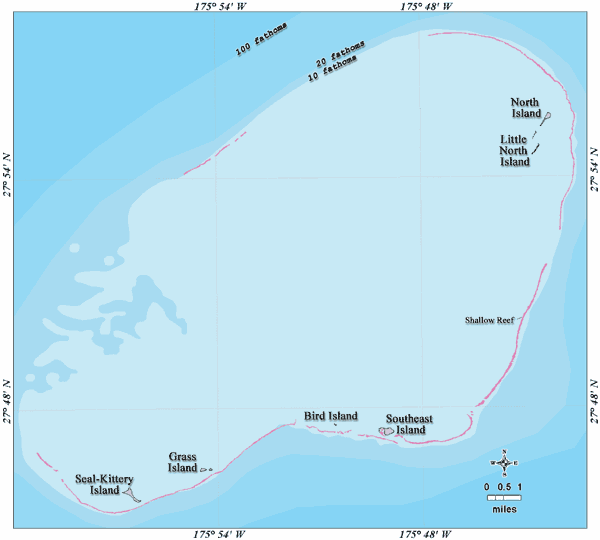
Deutsch: Bathymetrische Karte des Pearl-und-Hermes-Atolls, Nordwestliche Hawaii-Inseln
English: Bathymetric map of Pearl and Hermes Atoll, Northwestern Hawaiian Islands |
| 日期 | not specified |
| 来源 | http://www.papahanaumokuakea.gov/imagery/graphicsmaps.html |
| 作者 | Christine Taylor, NOAA's National Marine Sanctuary Program |
| 授权 (二次使用本文件) |
credit to NOAA is preferred |
许可协议
本图像属于公有领域,因该作品最初来自于美国国家海洋和大气管理局职员的职务作品。
|
原始上传日志
Original Uploader was Ratzer (talk) at 5 July 2006.
15:35, 5 July 2006 Ratzer (Talk | contribs) (http://hawaiireef.noaa.gov/imagery/graphicmaps.html)
文件历史
点击某个日期/时间查看对应时刻的文件。
| 日期/时间 | 缩略图 | 大小 | 用户 | 备注 | |
|---|---|---|---|---|---|
| 当前 | 2007年2月21日 (三) 11:30 | | 600 × 540(18 KB) | Telim tor | == Information == {{Information |Description=en: Bathymetric map of Pearl and Hermes Atoll, Northwestern Hawaiian Islands de: Bathymetrische Karte des Pearl und Hermes-Atolls, Nordwestliche Hawaiische Inseln |Source=http://www.hawaiireef.noaa.gov/imagery |
文件用途
以下页面使用本文件:
全域文件用途
以下其他wiki使用此文件:
- de.wikipedia.org上的用途
- en.wikipedia.org上的用途
- eo.wikipedia.org上的用途
- frr.wikipedia.org上的用途
- gl.wikipedia.org上的用途
- haw.wikipedia.org上的用途
- ja.wikipedia.org上的用途
- lt.wikipedia.org上的用途
- nl.wikipedia.org上的用途
- pl.wikipedia.org上的用途
- pt.wikipedia.org上的用途
- ru.wikipedia.org上的用途
- uk.wikipedia.org上的用途
- vi.wikipedia.org上的用途