
File:Pind-Meglen.png
此为最大尺寸。
Pind-Meglen.png (200 × 204像素,文件大小:23 KB,MIME类型:image/png)
摘要
| 描述 |
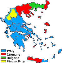
Approximative area (yellow) proposed by Alcibiades Diamandi for an eventual puppet-state called "Principality of the Pindus" in northern Greece under Italian occupation (this name was initially used in 1917 for another similar italian project). Diamandi's attempt of statehood had neither definite territory nor any borders, and never came close to realization; the yellow area in this map is likely to cover the maximalist area of the "Principality". |
| 来源 | 自己的作品, since a hand-drawn boundary (1942 or 1943) surimposed on a map of the Aromanians areas in Balkans, found & seen in the library of the Military Museum of Bucharest. |
| 作者 | Spiridon MANOLIU |
许可协议
| 本作品采用知识共享CC0 1.0 通用公有领域贡献许可协议授权。 | |
| 采用本宣告发表本作品的人,已在法律允许的范围内,通过在全世界放弃其对本作品拥有的著作权法规定的所有权利(包括所有相关权利),将本作品贡献至公有领域。您可以复制、修改、传播和表演本作品,将其用于商业目的,无需要求授权。
|
文件历史
点击某个日期/时间查看对应时刻的文件。
| 日期/时间 | 缩略图 | 大小 | 用户 | 备注 | |
|---|---|---|---|---|---|
| 当前 | 2010年5月3日 (一) 17:39 | | 200 × 204(23 KB) | Spiridon Ion Cepleanu | {{Information |Description={{ro|1=Principatul de Pind si Meglen, 1941-1943}} |Source={{own}} |Author=Spiridon MANOLIU |Date= |Permission= |other_versions= }} Category:Maps of Greece |
文件用途
以下页面使用本文件:
全域文件用途
以下其他wiki使用此文件:
- cs.wikipedia.org上的用途
- en.wikipedia.org上的用途
- fa.wikipedia.org上的用途
- it.wikipedia.org上的用途
- ka.wikipedia.org上的用途
- lv.wikipedia.org上的用途
- sq.wikipedia.org上的用途