
File:Pusan Perimeter.jpg
此为最大尺寸。
Pusan_Perimeter.jpg (350 × 572像素,文件大小:52 KB,MIME类型:image/jpeg)
摘要
| 描述 |
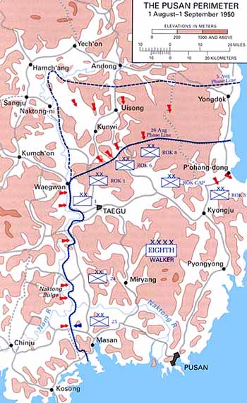
English: Map of the Pusan Perimeter, August 1950. |
| 来源 | This map was created by the Center for Military History and used in the brochure "The Korean War: The Outbreak" located at [1]. |
| 作者 | United States Army Center of Military History |
| 其他版本 |
|
.jpg)
.jpg)
.jpg)
.jpg)
.jpg)
许可协议
| This image is in the public domain because it contains materials that originally came from the United States Army Center of Military History, subject to the following qualification.
Note: The images of all badges, insignia, decorations and medals on the "CMH Online" web site are produced by the United States Army Institute of Heraldry and protected by Title 18, United States Code, Section 704 and the Code of Federal Regulations (32 CFR, Part 507). Permission to use these images for commercial purposes must be obtained from The Institute of Heraldry prior to their use. |

|
原始上传日志
原始描述頁面位於這裡。下列使用者名稱均來自en.wikipedia。
文件历史
点击某个日期/时间查看对应时刻的文件。
| 日期/时间 | 缩略图 | 大小 | 用户 | 备注 | |
|---|---|---|---|---|---|
| 当前 | 2008年3月15日 (六) 01:13 | | 350 × 572(52 KB) | Donostiarra~commonswiki | {{Information |Description={{en|Map of the Pusan Perimeter, August 1950. This map was created by the Center for Military History and used in the brochure "The Korean War: The Outbreak" located at [http://www.army.mil/cmh-pg/brochures/KW-Outbreak/outbreak. |
文件用途
没有页面链接到本图像。
全域文件用途
以下其他wiki使用此文件:
- ar.wikipedia.org上的用途
- cs.wikipedia.org上的用途
- de.wikipedia.org上的用途
- en.wikipedia.org上的用途
- es.wikipedia.org上的用途
- fr.wikipedia.org上的用途
- he.wikipedia.org上的用途
- ko.wikipedia.org上的用途
- no.wikipedia.org上的用途
- pl.wikipedia.org上的用途
- pt.wikipedia.org上的用途
- ru.wikipedia.org上的用途
- simple.wikipedia.org上的用途
- uk.wikipedia.org上的用途
- vi.wikipedia.org上的用途