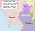
File:Saharat Thai Doem map.png

本预览的尺寸:663 × 600像素。 其他分辨率:265 × 240像素 | 531 × 480像素 | 962 × 870像素。
原始文件 (962 × 870像素,文件大小:189 KB,MIME类型:image/png)
文件历史
点击某个日期/时间查看对应时刻的文件。
| 日期/时间 | 缩略图 | 大小 | 用户 | 备注 | |
|---|---|---|---|---|---|
| 当前 | 2017年5月24日 (三) 13:01 |  | 962 × 870(189 KB) | Xufanc | Undid malicious revision by User:Shoshui |
| 2016年3月12日 (六) 03:37 |  | 962 × 870(167 KB) | Shoshui | Reverted to version as of 07:52, 6 November 2015 (UTC) | |
| 2015年12月15日 (二) 09:37 |  | 962 × 870(193 KB) | Xufanc | Corrected title | |
| 2015年12月15日 (二) 09:08 |  | 962 × 870(194 KB) | Xufanc | Other wording | |
| 2015年12月15日 (二) 08:59 |  | 962 × 870(208 KB) | Xufanc | Other wording | |
| 2015年11月9日 (一) 01:57 |  | 962 × 870(208 KB) | Xufanc | status unclear region | |
| 2015年11月7日 (六) 03:03 |  | 962 × 870(208 KB) | Xufanc | Status unclear region | |
| 2015年11月6日 (五) 07:52 |  | 962 × 870(167 KB) | Xufanc | Mandalay and Taunggiy was as far as the Thai troops advanced, but the map is about the parts annexed by Thailand as 'Saharat Thai Doem'. It is not a map of the farthest penetration of the Phayap Army | |
| 2015年9月14日 (一) 06:25 |  | 962 × 870(166 KB) | Shoshui | The area include Mandalay and Taunggyi. | |
| 2015年9月14日 (一) 06:16 |  | 962 × 870(166 KB) | Shoshui | The area include Mandalay and Taunggyi. |
文件用途
以下页面使用本文件:
全域文件用途
以下其他wiki使用此文件:
- en.wikipedia.org上的用途
- es.wikipedia.org上的用途
- fr.wikipedia.org上的用途
- it.wikipedia.org上的用途
- my.wikipedia.org上的用途
- ru.wikipedia.org上的用途
- th.wikipedia.org上的用途
- uk.wikipedia.org上的用途
- vi.wikipedia.org上的用途

