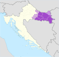
File:Slavonia.svg

此SVG文件的PNG预览的大小:619 × 599像素。 其他分辨率:248 × 240像素 | 496 × 480像素 | 793 × 768像素 | 1,058 × 1,024像素 | 2,115 × 2,048像素 | 1,098 × 1,063像素。
原始文件 (SVG文件,尺寸为1,098 × 1,063像素,文件大小:798 KB)
文件历史
点击某个日期/时间查看对应时刻的文件。
| 日期/时间 | 缩略图 | 大小 | 用户 | 备注 | |
|---|---|---|---|---|---|
| 当前 | 2020年7月19日 (日) 10:17 |  | 1,098 × 1,063(798 KB) | Koreanovsky | When we talk about modern-day Slavonia, we usually refer to the region that is colored in dark purple. There is no exact definition, since those regions are historical and do not have any official status, but mostly we do not include those parts that are striped, such as in the region of small Moslavina. |
| 2014年6月7日 (六) 18:28 |  | 1,098 × 1,063(751 KB) | DIREKTOR | Fixed borders, removed a number of issues. | |
| 2014年6月7日 (六) 10:49 |  | 1,098 × 1,063(798 KB) | DIREKTOR | Corrections. | |
| 2014年6月7日 (六) 09:09 |  | 1,098 × 1,063(798 KB) | DIREKTOR | Small fix. | |
| 2014年6月7日 (六) 07:30 |  | 1,098 × 1,063(799 KB) | DIREKTOR | Small-scale modifications. | |
| 2014年6月6日 (五) 11:58 |  | 512 × 496(268 KB) | DIREKTOR | Colours | |
| 2012年3月7日 (三) 11:12 |  | 1,098 × 1,063(440 KB) | Tomobe03 |
文件用途
以下页面使用本文件:
全域文件用途
以下其他wiki使用此文件:
- ar.wikipedia.org上的用途
- bg.wikipedia.org上的用途
- br.wikipedia.org上的用途
- bs.wikipedia.org上的用途
- ca.wikipedia.org上的用途
- de.wikipedia.org上的用途
- de.wikivoyage.org上的用途
- de.wiktionary.org上的用途
- en.wikipedia.org上的用途
- eo.wikipedia.org上的用途
- es.wikipedia.org上的用途
- et.wikipedia.org上的用途
- eu.wikipedia.org上的用途
- fa.wikipedia.org上的用途
- hr.wikipedia.org上的用途
- hu.wikipedia.org上的用途
- it.wikivoyage.org上的用途
- ko.wikipedia.org上的用途
- la.wikipedia.org上的用途
- li.wikipedia.org上的用途
- lv.wikipedia.org上的用途
- mzn.wikipedia.org上的用途
- pl.wikipedia.org上的用途
- pl.wikivoyage.org上的用途
- ru.wikipedia.org上的用途
- ru.wikivoyage.org上的用途
- sh.wikipedia.org上的用途
- sr.wikipedia.org上的用途
- sv.wikipedia.org上的用途
- uk.wikipedia.org上的用途
- ur.wikipedia.org上的用途
- www.wikidata.org上的用途

