
File:TVA-sites-map.png
此为最大尺寸。
TVA-sites-map.png (439 × 325像素,文件大小:20 KB,MIME类型:image/png)
摘要
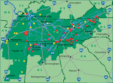
| 描述 | Map of Tennessee Valley Authority sites. Key: red: dam, magenta: nuclear power plant, orange: fossil-fuel plant |
| 来源 | tva.com |
| 作者 | Tennessee Valley Authority |
许可协议
| This image is a work of a United States Tennessee Valley Authority employee, taken or made as part of that person's official duties. As a work of the U.S. federal government, the image is in the public domain in the United States. |
原始上传日志
(All user names refer to en.wikipedia)
- 2005-05-18 01:09 ChrisRuvolo 439×325×8 (19706 bytes) Map of [[Tennessee Valley Authority]] sites. Key: red: [[dam]], magenta: [[nuclear power plant]] orange: [[fossil fuel]] plant Source: [http://www.tva.gov/sites/sites_ie2.htm] [http://www.tva.gov/sites/images/sitesmap3.gif], converted to PNG {{PD-USG
文件历史
点击某个日期/时间查看对应时刻的文件。
| 日期/时间 | 缩略图 | 大小 | 用户 | 备注 | |
|---|---|---|---|---|---|
| 当前 | 2015年8月9日 (日) 10:03 | | 439 × 325(20 KB) | Kopiersperre | png repaired |
| 2007年5月26日 (六) 11:49 |  | 439 × 325(19 KB) | Kordas | {{Information |Description=Map of en:Tennessee Valley Authority sites. Key: red: en:dam, magenta: en:nuclear power plant orange: en:fossil fuel plant Source: [http://www.tva.gov/sites/sites_ie2.htm] [http://www.tva.gov/sites/images |
文件用途
以下页面使用本文件:
全域文件用途
以下其他wiki使用此文件:
- da.wikipedia.org上的用途
- es.wikipedia.org上的用途
- he.wikipedia.org上的用途
- nl.wikipedia.org上的用途
- no.wikipedia.org上的用途