
File:Topographic map of Åland.svg

此SVG文件的PNG预览的大小:681 × 516像素。 其他分辨率:317 × 240像素 | 634 × 480像素 | 1,014 × 768像素 | 1,280 × 970像素 | 2,560 × 1,940像素。
原始文件 (SVG文件,尺寸为681 × 516像素,文件大小:172 KB)
摘要
| 描述 |
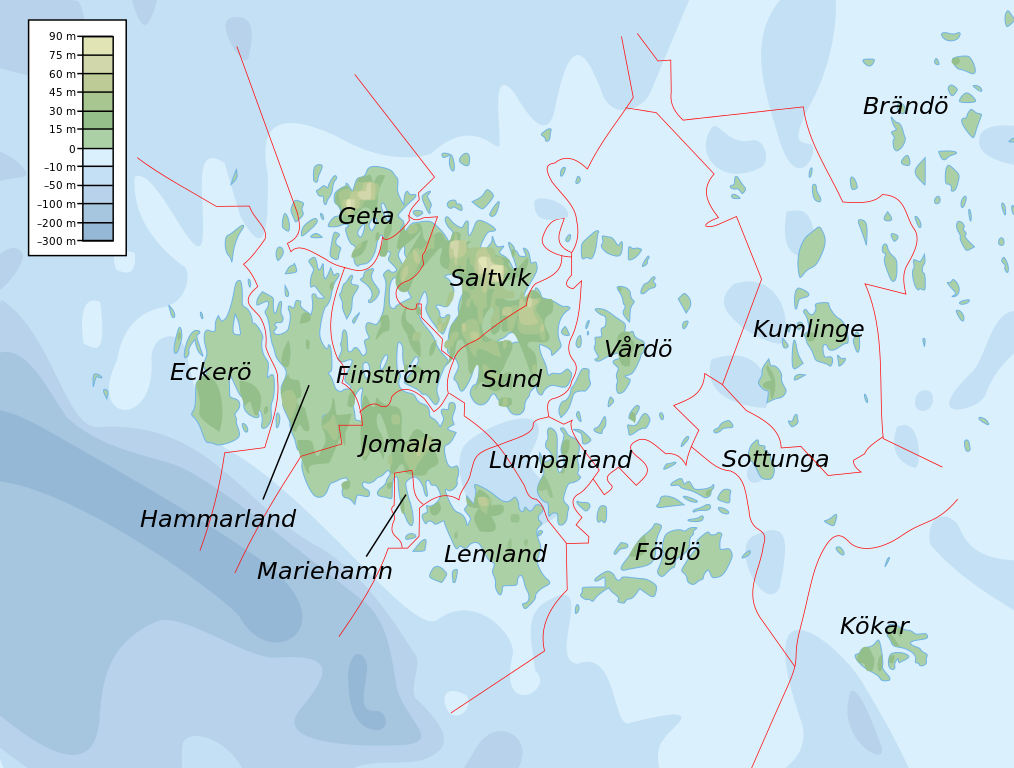
English: Topographic map of the Åland Islands.
Français : Carte topographique des îles d'Åland.
Suomi: Ahvenanmaan topografinen kartta.
Approximate limits:
|
| 日期 | |
| 来源 |
Self-made in Inkscape. Boundaries and municipality borders based on Image:Alandmunicipalities.png. Topography based on public domain GLOBE data from NOAA (http://www.ngdc.noaa.gov/mgg/topo/gltiles.html). Bathymetry adapted after a small slice from T. Seifert, F. Tauber, B. Kayser: 2001: "A high resolution spherical grid topography of the Baltic Sea – 2nd edition", Baltic Sea Science Congress, Stockholm 25-29. November 2001, Poster #147, www.io-warnemuende.de/iowtopo. Colors and overall look based on maps by User:Bamse. |
| 作者 | Mysid |
| 其他版本 | 此文件衍生的作品: Aland EU.svg |

|
此SVG檔案包含可翻譯至您的語言的内嵌文字,可以使用任何可用SVG編輯器、文本編輯器或SVG翻譯工具來翻譯。詳情請見:關於翻譯SVG檔案。 |
许可协议
我,本作品著作权人,特此采用以下许可协议发表本作品:

|
已授权您依据自由软件基金会发行的无固定段落及封面封底文字(Invariant Sections, Front-Cover Texts, and Back-Cover Texts)的GNU自由文件许可协议1.2版或任意后续版本的条款,复制、传播和/或修改本文件。该协议的副本请见“GNU Free Documentation License”。 |
This file is licensed under the Creative Commons Attribution-Share Alike 4.0 International, 3.0 Unported, 2.5 Generic, 2.0 Generic and 1.0 Generic license.
- 您可以自由地:
- 共享 – 复制、发行并传播本作品
- 修改 – 改编作品
- 惟须遵守下列条件:
- 署名 – 您必须对作品进行署名,提供授权条款的链接,并说明是否对原始内容进行了更改。您可以用任何合理的方式来署名,但不得以任何方式表明许可人认可您或您的使用。
- 相同方式共享 – 如果您再混合、转换或者基于本作品进行创作,您必须以与原先许可协议相同或相兼容的许可协议分发您贡献的作品。
您可以选择您需要的许可协议。
文件历史
点击某个日期/时间查看对应时刻的文件。
| 日期/时间 | 缩略图 | 大小 | 用户 | 备注 | |
|---|---|---|---|---|---|
| 当前 | 2008年2月12日 (二) 11:06 | | 681 × 516(172 KB) | Mysid | border wouldn't work |
| 2008年2月12日 (二) 11:05 |  | 681 × 516(172 KB) | Mysid | {{inkscape}} {{Information |Description={{en|Topographic map of the Åland Islands.}} {{fi|Ahvenanmaan topografinen kartta.}} |Source=Self-made in Inkscape.<br/>Boundaries and municipality borders based on [[:Imag |
文件用途
以下页面使用本文件:
全域文件用途
以下其他wiki使用此文件:
- ar.wikipedia.org上的用途
- az.wiktionary.org上的用途
- ba.wikipedia.org上的用途
- be.wikipedia.org上的用途
- bs.wikipedia.org上的用途
- de.wikipedia.org上的用途
- en.wikipedia.org上的用途
- et.wikipedia.org上的用途
- fi.wikipedia.org上的用途
- fo.wikipedia.org上的用途
- fr.wikipedia.org上的用途
- fy.wikipedia.org上的用途
- gd.wikipedia.org上的用途
- he.wikipedia.org上的用途
- is.wikipedia.org上的用途
- kk.wikipedia.org上的用途
- ky.wikipedia.org上的用途
- lb.wikipedia.org上的用途
- mi.wikipedia.org上的用途
- no.wikipedia.org上的用途
- os.wikipedia.org上的用途
- rue.wikipedia.org上的用途
- ru.wikipedia.org上的用途
- simple.wiktionary.org上的用途
- sv.wikipedia.org上的用途
- uk.wikipedia.org上的用途