
File:Trinity crater (annotated) 2.jpg
本预览的尺寸:700 × 599像素。 其他分辨率:280 × 240像素 | 561 × 480像素。
原始文件 (800 × 685像素,文件大小:193 KB,MIME类型:image/jpeg)
_2.jpg?uselang=zh)
_2.jpg?uselang=zh)
_2.jpg?action=history&uselang=zh)
_2.jpg)
| 描述 |
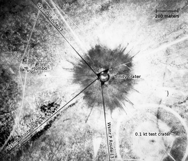
English: White Sands, New Mexico. Aerial view of the aftermath of the Trinity test, 28 hours after the explosion. The smaller crater to the southeast is from the earlier detonation of 100 tons of TNT on May 7, 1945. To the left of the crater can be seen the "Jumbo" container, unharmed, and its collapsed tower (a vertical line). |
| 日期 | (UTC) |
| 来源 | |
| 作者 |
|
| 这是一张修改过的图片,这意味着它已在原版本的基础上通过软件进行了编辑,改动内容:Road names, scale and annotations added。其原始版本为:Trinity crater.jpg。修改者:Bomazi。
|
| 我,本作品著作权人,释出本作品至公有领域。这适用于全世界。 在一些国家这可能不合法;如果是这样的话,那么: 我无条件地授予任何人以任何目的使用本作品的权利,除非这些条件是法律规定所必需的。 |
文件历史
点击某个日期/时间查看对应时刻的文件。
| 日期/时间 | 缩略图 | 大小 | 用户 | 备注 | |
|---|---|---|---|---|---|
| 当前 | 2011年1月27日 (四) 04:37 | | 800 × 685(193 KB) | Bomazi | {{Information |Description={{en|White Sands, New Mexico. Aerial view of the aftermath of the Trinity test, 28 hours after the explosion. The smaller crater to the southeast is from the earlier detonation of 100 tons of TNT on May 7, 1945. To the left of t |
文件用途
以下页面使用本文件:
全域文件用途
以下其他wiki使用此文件:
- de.wikipedia.org上的用途
- en.wikipedia.org上的用途
- fa.wikipedia.org上的用途
- fr.wikipedia.org上的用途
- he.wikipedia.org上的用途
- hu.wikipedia.org上的用途
- uz.wikipedia.org上的用途
_2.jpg)