
File:US Overflight Fee Map.png
此为最大尺寸。
US_Overflight_Fee_Map.png (375 × 272像素,文件大小:28 KB,MIME类型:image/png)
摘要
| 描述 |
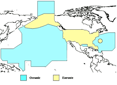
English: A map of the regions where the United States charges overflight fees. Yellow is where higher "enroute" fees are charged. Blue is where "oceanic" fees are charged. The colored regions of this map correspond to the regions where the US has delegated authority by the ICAO to control air traffic, including over international waters. |
| 日期 | 未知日期 |
| 来源 | http://www.faa.gov/about/office_org/headquarters_offices/aba/overflight_fees/ |
| 作者 | Federal Aviation Administration |
许可协议
|
|
 |
文件历史
点击某个日期/时间查看对应时刻的文件。
| 日期/时间 | 缩略图 | 大小 | 用户 | 备注 | |
|---|---|---|---|---|---|
| 当前 | 2014年8月9日 (六) 02:52 | | 375 × 272(28 KB) | AHeneen | User created page with UploadWizard |
文件用途
以下页面使用本文件:
全域文件用途
以下其他wiki使用此文件:
- af.wikipedia.org上的用途
- en.wikipedia.org上的用途
- fr.wikipedia.org上的用途
- it.wikipedia.org上的用途
- ja.wikipedia.org上的用途